Physical collocation
The physical collocation tools associate individual observations from distinct sensors, taking into account instrument viewing geometry.
Each physical collocation program supports a pair of sensors, one considered the master and the other the follower. The master is typically the instrument that has the larger spatial footprint.
Collocation requires as input a data file from each sensor that supplies geolocation information. The required type of file varies by sensor; for example, collocating MODIS data requires use of a MOD03 HDF4 file as input.
Collocation output provides for each master observation a list of follower observations that overlap spatially. For most programs this information is provided via a NetCDF file, but some programs still produce an older HDF4 output format. Use of the HDF4 format is being phased out and will be eliminated in the near future.
More complete documentation of these tools is coming soon. The following table
indicates what master/follower combinations are currently supported. The
program name to use consists of a combination of the master then follower
name; for example modcalip for MODIS-CALIPSO or ahiviirs for AHI-VIIRS.
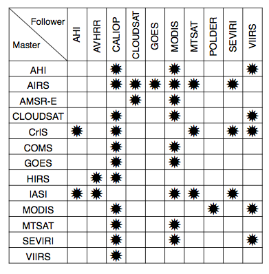
Currently supported sensor combinations