GOES-R extends its mission from orbit to classroom
After a successful mid-November launch, the GOES-R weather satellite — now GOES-16 — has reached its destination more than 22,000 miles from Earth. In approximately two months, the Geostationary Operational Environmental Satellite (GOES), a joint program between NASA and the National Oceanic and Atmospheric Administration (NOAA), will be in a lock-step rotation with the Earth and provide continuous weather coverage over the continental US.
As researchers and engineers now work to get the system online and calibrated, school teachers from around the country are already taking their experiences from the launch back to the classroom, through a multi-year program spearheaded by Margaret Mooney, director of education and public outreach at the UW-Madison Cooperative Institute for Meteorological Satellite Studies (CIMSS). That program culminated in a two-day workshop at the launch.

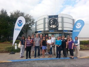
School teachers from around the country gathered at Kennedy Space Center in Florida to learn about GOES-R and share ways to bring meteorological science into the classroom. Photo by: Margaret Mooney CIMSS EPO
To Mooney, the GOES-R project is an exceptional and grassroots way to reach students through their teachers and further engage them in science, technology, engineering and mathematics (STEM).
“Every aspect of STEM is represented in many ways,” says Mooney. “The science part is the biggest component and is well-represented through the design of the experiments and the data that will be used in atmospheric, meteorological, and climate sciences in teachers’ classrooms.”
Mooney has been working with teachers through the GOES-R Education Proving Ground, which began three years ago with six core educators, including Brian Witthun and Craig Phillips, eighth grade science teachers at Jack Young Middle School in Baraboo, Wisconsin. They were among 23 educators from around the US to participate in the CIMSS program and witness the launch at Cape Canaveral, Florida.
“As a teacher, I feel it is important for our students to see the connection between weather forecasts and how we are able to get that information using satellites,” says Phillips. “Our lessons focus on the science of satellites and how improved weather data makes for more accurate predictions and ultimately helps save lives.”
Prior to the GOES-R launch, Witthun and Phillips taught sections about satellite meteorology and how it relates to numerous other scientific fields in their classrooms. During the planning and construction phases of GOES-R, the middle school teachers collaborated with staff at CIMSS and the NOAA GOES-R Education Proving Ground to create lesson plans and online tools for students to use for different units on weather, meteorology, and satellites. The online tools teach students about GOES-R and its ability to capture high resolution images, while other lessons focus on basic principles of satellite meteorology such as resolution and image coloring. Witthun and Phillips shared their four lesson plans with teacher colleagues at the launch workshop and discussed ways to teach students about satellites and the science behind atmospheric phenomena.
“It has been exciting to be a part of the GOES-R mission from early on,” says Phillips. “We’ve had the fortune to learn about every aspect of the program and we are able to use it to build a successful lesson plan that will resonate with our students.”
The two Wisconsin teachers agree: having seen and experienced the GOES-R launch in person will benefit their students down the road.
“Getting to see the launch really brings everything full-circle,” says Phillips. “Whenever you’re teaching something you’re passionate about, and when you are involved in the process like we have been, that enthusiasm translates to the classroom and the kids pick up on that as well.”

The GOES-R geosynchronous satellite hosts a suite of new imaging tools that will help improve weather forecasts. Photo credit: NOAA
The GOES-R weather satellite is the next step in the evolution of geostationary weather satellites, with the first launching more than 40 years ago. Scientists at CIMSS have been involved with each generation of geostationary satellite since imagers were first placed on orbiting satellites in the 1960s.
Compared to previous geostationary imagers, the Advanced Baseline Imager (ABI) on GOES-R has three times the number of spectral bands available to view different parts of the Earth’s atmosphere and weather patterns. GOES-R, via the ABI, will also have four times greater spatial resolution compared to current satellites in orbit and will capture data five times faster, sending images of Earth as often as every 30 seconds. The upgraded components of the GOES-R mission will give researchers and forecasters the tools they need to improve weather predictions and increase warning times.
In addition to the ABI, GOES-R includes the Geostationary Lightning Mapper (GLM), which can track lightning activity to determine if a storm is intensifying and capable of producing tornados. Other instruments will monitor space weather such as solar winds and flares capable of damaging other satellites, disrupting communications systems, and power grids on Earth.

GOES-R launches from Cape Canaveral, Florida at the very last minute of the launch window, 6:42 p.m. Photo credit: NASA
Following its launch on November 19, 2016, the GOES-R satellite is expected to send back its first data and images in early 2017. GOES-R is the first in a series of new geostationary satellites scheduled to be launched in the coming years through 2025.
Looking ahead, Mooney is encouraged by the excitement surrounding the GOES-R launch and its ability to reach beyond its meteorological mission.
“Through programs like GOES-R,” says Mooney. “We hope to get more young people engaged in STEM fields and inspire them toward scientific careers so that they can tackle challenges facing society.”
by Eric Verbeten
