UW satellite pioneer garners top atmospheric sciences award
Pushing the boundaries of satellite remote sensing, Bill Smith has been a catalyst for increasingly sophisticated instruments and methods to gather good data about Earth’s atmosphere in order to improve weather forecasts.

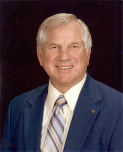
William L. Smith
A senior scientist at the University of Wisconsin-Madison Space Science and Engineering Center, professor emeritus with the Department of Atmospheric and Oceanic Sciences, and distinguished professor at Hampton University, Smith is responsible for “visionary and pioneering hyperspectral resolution sounding techniques”: techniques that are being used on current polar-orbiting satellites and planned for future polar-orbiting and geostationary satellites.
It is this work – sustained over the course of 50 years – that has landed him the 2016 Losey Atmospheric Sciences Award. Nominated by his peers and awarded by the American Institute of Aeronautics and Astronautics (AIAA), the honor is given in memory of Captain Robert Losey, a United States Army observer and the first casualty of World War II. The award recognizes outstanding contributions to the atmospheric sciences as applied to the advancement of aeronautics and astronautics.
A scientist and an aviator, Smith has professional and personal interests in better weather forecasts. The sounding techniques he has pioneered are crucial for many fields, including aviation, where measures of the stability of the atmosphere are necessary to predict turbulence.
According to National Weather Service (NWS) director Louis Uccellini, “Bill has been at the forefront of satellite sounding of the atmosphere and its application to weather forecasting since its earliest days. There are many within the atmospheric science community today who consider Smith to be the father of satellite atmospheric sounding.”
Smith’s legacy extends back to the early NASA Nimbus missions – in 1972 he was the principal investigator for a radiometer that flew on Nimbus 5, successfully measuring carbon dioxide, temperature, and water vapor content in the troposphere and lower stratosphere.
Since then, he has spearheaded the field’s progression to hyperspectral soundings, collecting increasingly accurate and detailed information about the vertical structure of the atmosphere with instruments on satellites, aircraft, or on the ground. In addition to temperature and moisture profiles at different levels of the atmosphere, hyperspectral infrared measurements are providing precise information on greenhouse gases, giving scientists a long view of changing climate.
“All of the work that I’ve done that led to this award was done at the UW-Madison,” says Smith. But what makes it such a great honor for Smith is the association with “brilliant scientists” who received the award before him. Among them are Harry Wexler, Jule Charney, Moustafa Chahine and “Verner Suomi, the most notable,” says Smith. “They were heavily involved in atmospheric sounding instruments and retrievals and that’s what makes it so meaningful.”
An alumnus of the UW-Madison Department of Meteorology, Smith received his PhD in 1966. Even then, he was examining the possibilities of using meteorological satellites to infer the temperature structure of the atmosphere from infrared radiation observations.
While studying in Madison, Smith would cross paths with Suomi, another giant in the field of satellite meteorology, who founded SSEC in 1965. Their professional interests would frequently converge over the next three decades.
Smith spent 11 years in Washington DC, from the mid-1960s until the mid-1970s, leading several satellite programs for the National Oceanic and Atmospheric Administration (NOAA). During that time, both he and Suomi were working on different aspects of the same program: the Visible-Infrared Spin-Scan Radiometer (VISSR) Atmospheric Sounder (VAS) that could obtain atmospheric soundings as well as images from the early geostationary satellites.
Smith’s group in Washington DC was working on the program from the data processing point of view, and Suomi, in Madison, was working on it from the instrument point of view.
“We thought, ‘Why are we doing this separately?’” Smith recalls. “It just made sense to join our forces to improve the VAS retrievals.”

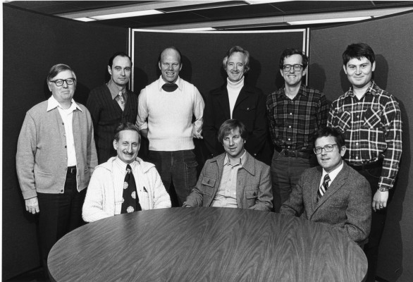
The first federal research group arrived in Madison in 1976 to collaborate with SSEC scientists. Back row, from left: Leroy Herman, Frederick Nagle, John Lewis, Hugh Howell, Geary Callan, William Togstad. Front row, from left: Harold Woolf, William Smith, Christopher Hayden. Credit: CIMSS.
And so in 1976, working with Suomi, NOAA, and UW-Madison administrators to iron out the details, Smith moved eight federal scientists, plus himself, to Madison to work alongside university researchers – a move that, over the years, has repeatedly proven its value in the form of better environmental data and better weather forecasting tools. That move would result in the establishment of NOAA’s Cooperative Institute for Meteorological Satellite Studies (CIMSS) at UW-Madison, with Smith as its first director.
“Beyond coming back to my alma mater,” says Smith, “I wanted to come here because I saw the application of McIDAS (SSEC’s Man-computer Interactive Data Access System developed for data visualization) for editing bad data and displaying sounding product results.”
McIDAS was still in beta in the 1970s, but Smith, like Suomi, saw its potential, “not just for producing winds, but for quality controlling and for getting sounding information to forecasters.”
The story of the McIDAS innovation spread beyond SSEC and Wisconsin. After demonstrating its capabilities, the SSEC research and engineering teams installed the first McIDAS system at the National Severe Storms Forecast Center (now the NOAA Storm Prediction Center) in Kansas City, Missouri, in 1982. It was the first time “we were able to get forecasters to look at and actually use atmospheric sounding data,” says Smith. “We made derived product images so they were not looking at numbers, but pictures of atmospheric features.”
It was a monumental advance: McIDAS, by providing a way to animate satellite images, made the data usable to NWS forecasters who were interested in improving forecasts for severe weather.
Smith has been at the leading edge of developing atmospheric sounding systems flown by the world’s premier weather agencies. In fact, generations of satellite instruments – for polar orbiting and geostationary satellites – had their genesis with Smith and his SSEC colleagues.
For example, the Cross-track Infrared Sounder (CrIS) on the Suomi National Polar-orbiting Partnership (NPP) satellite is slated for operations on the 2017 Joint Polar Satellite System: It is a direct descendent of polar-orbiting sounders developed at SSEC. Data from CrIS will improve model forecasts, aiding in both short-term and long-term weather forecasting, and provide more information about atmospheric chemistry.
On the geostationary side, the United States has yet to include a hyperspectral sounder on one of its satellites, but China and Europe are proceeding with this capability – its lineage linked directly to the SSEC model. Smith is certain that both instruments will provide “a real demonstration of capabilities, and then maybe we’ll do it.”
“All of this work and development was really from here,” says Smith. “My name may be on the award, but there are many people at SSEC who deserve recognition for it.”
By Jean Phillips
