Research-to-operations: NOAA, NASA, industry leaders partner with UW scientists to improve weather satellites
University scientists are often on the cutting edge of scientific discovery. It’s not unusual, then, for federal agencies or industry leaders to partner with them – whether it is to advance agricultural and farming practices or medical discovery and breakthroughs. Each discovery is typically bolstered by years of research before it reaches the public eye.
Take the next generation of weather satellites, for example…
During the summer of 2013, scientists at the UW-Madison Cooperative Institute for Meteorological Satellite Studies (CIMSS) submitted several special requests to the National Oceanic and Atmospheric Administration (NOAA) to shift GOES-14, a geostationary weather satellite, from its back-up mode to its experimental super rapid scan operations (SRSO-R) mode.
One of those requests occurred on August 21, on the heels of a NOAA Storm Prediction Center forecast that highlighted the potential for severe thunderstorms across the upper Mississippi Valley and the upper Great Lakes regions.
Having seen the forecast, GOES expert Tim Schmit, a NOAA Advanced Satellite Products Branch (ASPB) scientist working at CIMSS, anticipated a fast-moving cold front across Wisconsin.

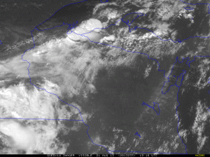
GOES-14 Imager SRSO-R visible imagery of convection over the Upper Midwest on 21 August 2013. Credit: Tim Schmit, NOAA ASPB.
As expected, the front triggered severe and rapidly evolving convection in the upper Midwest, providing a perfect opportunity to compare the routine scanning of operational satellites: relating GOES-13’s 15-30-minute image refresh rate to the special rapid scan, one-minute imaging of GOES-14.
According to Schmit, one of the most exciting aspects of the newest geostationary weather satellite, GOES-R – set for launch in early 2016 – is the improved rapid scan imaging capability, particularly in the mesoscale, convective environment. It will be a standard option on GOES-R, delivered via the Advanced Baseline Imager (ABI), the satellite’s primary instrument.
The ABI on GOES-R will provide enhanced and detailed imaging of Earth’s weather and environment on an unprecedented scale.
“We’ll be able to scan the continental United States (CONUS) every five minutes, but then also move to the mesoscale, where convection may be occurring, and get one-minute imagery with the rapid scan option,” explains Schmit. “And, we’ll still be able to capture full disk imagery of the hemisphere – all of this can happen nearly simultaneously because the scans are ‘interwoven’ in time. We can’t do this with the current GOES satellites.”
In contrast to the less frequent imagery of today, these rapid scan images will quickly prove their utility to researchers and forecasters dealing with weather events on the local scale.
The dramatic improvements in frequency, and spatial and spectral resolutions, will allow scientists to better predict the behavior of severe storms by combining satellite imagery and quantitative products with other technologies, such as radar, thereby increasing the accuracy of convective event forecasting.
With better satellite imagery, scientists can, for example, evaluate five-minute, ground-based radar alongside one-minute, satellite imagery in emerging convective environments. The satellite perspective can see rapidly cooling and expanding clouds, overshooting tops, and the development of rapid updrafts: Using the two tools together, Schmit explains, will increase our understanding and our ability to track storms with much more accuracy.
In the case of the August 2013 convection, notes Schmit, “We were able to see things with a much greater lead time.” An image-refresh rate of 15-30 minutes is too long when time is of the essence, weather conditions are quickly changing, and forecasters need to alert the public to potentially dangerous conditions.
The ABI, developed collaboratively over the last decade by university researchers at institutes such as CIMSS, with NOAA and NASA scientists along with private industry partners, will include 16 spectral bands that will capture more data at different frequencies across the electromagnetic spectrum. In comparison, the current GOES imager has only five spectral bands.
Scientists have had just a taste of the SRSO-R capabilities because the current GOES satellite is acting as a proxy for the future ABI. The actual imager promises to be even better.
The anticipated imaging capabilities of GOES-R are exciting to CIMSS scientists because of the expected improvements in different areas of environmental remote sensing — for early detection of smoke plumes from fires and biomass burning; fast and continuous monitoring of hurricane intensification, as in the case of Hurricane Sandy; and monitoring the interactions between phenomena such as smoke, clouds, and precipitation, to name a few.

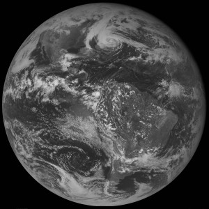
GOES-13 Imager full disk visible image of Hurricane Sandy on 28 October 2012 at 18 UTC. Credit: Tim Schmit, NOAA ASPB.
Another important instrument to be included on GOES-R is the Geostationary Lightning Mapper (GLM). The GLM will provide coverage of all lightning activity – cloud-to-ground as well as cloud-to-cloud.
Scientists have documented that rapid changes in lightning activity often accompany thunderstorms and hurricanes. Adding the new GLM measurements to existing measurements will improve thunderstorm and tornado forecasts and warnings.
Looking beyond the regular scans of CONUS, Schmit says that with ABI-like imagers on the recently launched Japanese Himawari satellite and those slated for inclusion on the next Korean KOMSAT and European geostationary satellites, we will have the potential to piece together some current gaps in coverage: creating a better view of developing weather over most of the globe.
Schmit is certain that the success of the GOES-R mission, as with those that came before it, hinges on the pivotal, well-established, research-to-operations partnerships. “We have university researchers working independently and in collaboration with federal scientists to conduct the basic and applied research, and contribute the ideas,” he says. “We have private industry to build the instruments, and we have government partners to provide oversight.”
The ProbSevere model, a recently developed product, is another important example of this cooperation at its best – NOAA and CIMSS scientists working with operational forecasters to perfect a new tool to predict the probability of severe weather occurring in the near-term. Forecasters provide direct feedback about overlays and desired features, which in turn are incorporated by researchers.
As a measure of the importance of the partnership, nearly all of the operational products on the current GOES series were developed at CIMSS or include significant contributions by CIMSS and/or NOAA ASPB scientists. In addition, nearly half of the expected ABI operational products on GOES-R have been developed by CIMSS scientists, frequently in collaboration with ASPB scientists.
NASA and NOAA estimate that economic benefits from the ABI, across its lifetime, will reach at least $4.6 billion, touching all those who are affected by hurricanes, tornadic storms, fires, and floods.
Adds Schmit, “We don’t know all the things that we’ll be able to do with the next generation satellites, instruments, and data, but this is an important time for forecasting that will provide many societal benefits.”
This article was originally published in the Winter 2015 issue of Through the Atmosphere.
By Jean Phillips
