Arctic sea ice rebound linked to meager wintertime cloud cover

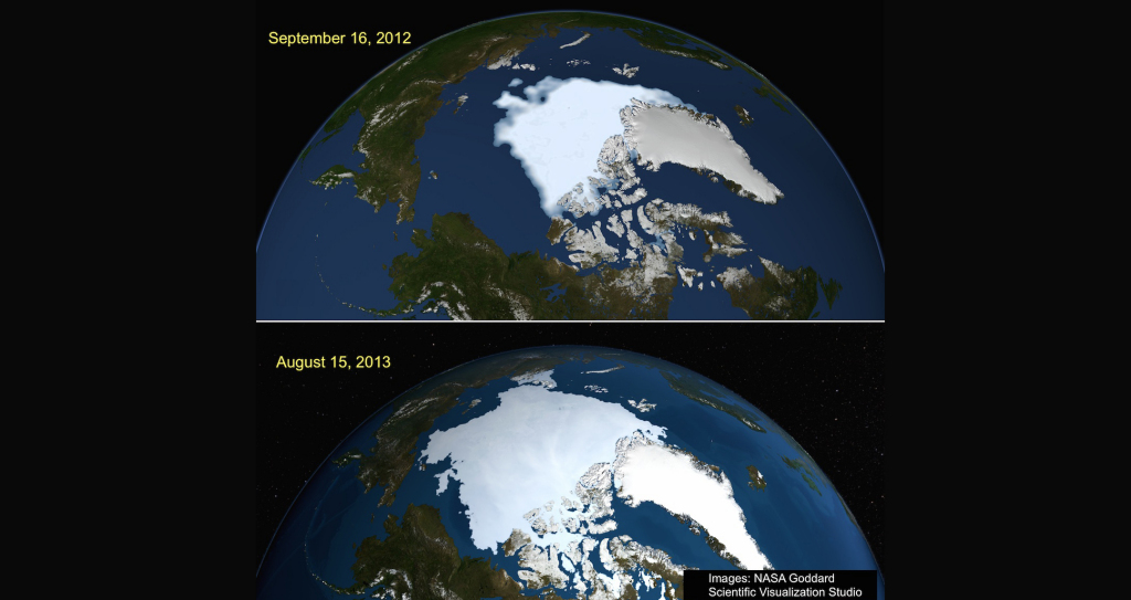
A figure illustrating Arctic sea ice from September 2012 and August 2013 developed at the NASA Goddard Scientific Visualization Studio (svs.gsfc.nasa.gov).
Each September, the total area of sea ice in the Arctic — also called the ice extent — is at its minimum level, gradually growing back as winter progresses. But in September 2012, the Arctic sea ice extent was even lower than usual: a record low.
By September 2013, the end of the following summer, things had rebounded dramatically. Scientists recorded more than 5 million square kilometers of ice, up from less than 4 million square kilometers — a 48 percent increase — from that time the previous year. Yet, it was still the fifth lowest September ice extent on record, and the sixth lowest extent ever recorded in more than 30 years of satellite observation.
Knowing that a variety of factors could be influencing that short-term but substantial rebound, a team at the University of Wisconsin Space Science and Engineering Center (SSEC) set out to study one possible cause: low cloud cover during preceding winter months.
The idea first occurred to the team, composed of SSEC scientist Yinghui Liu and NOAA Advanced Satellite Products Branch (ASPB) scientist Jeffrey Key, while working on another project, the NOAA Arctic Report Card. They noticed that cloud cover in January and February had been anomalously low, much lower than average, in 2013.
Since a great deal of Arctic sea ice — averaging 1-2 meters and up to 4 meters thick in places — survives the melt season, scientists can study it throughout the year. Of particular interest to Liu and Key was its horizontal fluctuations, or changes in ice extent. They decided to investigate whether anomalously low winter cloud cover could have influenced the September 2013 rebound in sea ice extent. The results of their study were published in the April 2014 issue of Environmental Research Letters.
Liu and Key knew it was critical to account for the darkness during the Arctic’s winter months, known as the “polar night.” Normally, one thinks of clouds as blocking sunlight and maintaining cool temperatures on the ground. When sun is not a factor, though, clouds have a greenhouse-like warming effect on the Earth’s surface, Key explained.
“If you go outside on a clear winter night and look up at the stars, it’s probably pretty cold,” he said. “What clouds do is kind of like what carbon dioxide does, or methane. Clouds are not a gas, but they have a greenhouse effect. The Earth, just like our bodies, is emitting longwave radiation. Clouds trap that and re-radiate it back to Earth.”
This process is known as the cloud radiative effect, or cloud forcing. It is because of this effect, Key said, that clouds warm the Earth’s surface at night, and, likewise, “if you don’t have clouds, most of that longwave radiation just escapes to space and the surface of the Earth cools.”
Liu and Key were not dealing with a small change in cloud cover, but up to 20 percent less cloud cover than average.
“That’s a big difference, especially in the coldest part of the winter,” said Key. “That turns into a lot of cooling, and more ice growth.”
The scientists estimated that in an area of 20 percent less cloud cover, ice could grow 45 centimeters more in two months.
For the study, Liu and Key constructed a simple model relating ice growth to cloud forcing, which they confirmed with several sets of data from aircraft and satellites. They further verified their results with a dataset on ice motion from winter through summer to see how the ice had actually moved, which gave them a much clearer idea of what was taking place, Key said.
A variety of studies have been conducted on the question of low ice extent: Some have examined temperature, which directly affects ice melt, while others looked at winds and ocean currents, since large amounts of ice can be degraded from ice motion and circulation. Freshwater, from major rivers that run through the Arctic, also has a melting effect.
But Liu and Key are the first to look at how below-average cloud cover in winter would affect sea ice extent in the upcoming summer.
Key said the inter-seasonal stretch of time might seem like “a big leap” to those of us in the mid-latitudes, but makes more sense when considering Arctic climate.
“In Wisconsin, for example, January snow depth is not a good predictor for snow in July. We know that, no matter what, in July there will be no snow. That’s not the same for the Arctic, because the ice is not going away,” Key explained. “It’s hard, but you can study Arctic sea ice eight months in advance, and people are doing just that.”
Among other applications, Key said, these types of studies bring scientists a step closer to understanding global climate change.
“Sea ice extent is a neatly packaged climate variable that people like to monitor because, with the help of satellites, it can very easily tell us the story of Arctic climate,” Key said, “which is important because it is changing much more rapidly than global climate.”
This idea, known as “arctic amplification,” is that phenomena in the Arctic will indicate later global climate trends. To understand the past, present, and future of our global environment, Liu and Key have their eyes on the sky.
“People need to pay attention to clouds,” Key said. “The January/February cloud cover anomaly may not completely explain the summer rebound of Arctic ice in 2013, but this is one factor that really seems to have had an influence.”
by Sarah Witman
