Quantitatively Monitoring Dust Events: Better Weather Prediction Ahead
By Zhengzheng Zhang
Dust storms occur more frequently now due to climatic variability and land-use change. During an outbreak, dust storms wreak havoc in cities and along major transportation routes. Dust pollution also threatens human health, raising the risk of heart, lung and other chronic diseases. In recent years, scientists have found that dust storms can also affect the formation of hurricanes and changes in climate.
To better protect people from dust storms and understand dust’s impact on climate, atmospheric scientists are using satellite observations to detect and predict dust events. One of the leading scientists in this area, Jun Li, works at the Cooperative Institute for Meteorological Satellite Studies (CIMSS), University of Wisconsin-Madison. Collaborating with scientists all over the world, Li’s team is developing a model that can simulate the radiative property of dust particles. A state-of-the-art technique, it quantitatively monitors dust layer thickness and particle size, resulting in better dust transport prediction.
“If you look at the [satellite] image [showing a dust storm] qualitatively by human eyes, you may identify: ok, this looks like dust. But this is not enough for scientific research, you have to quantitatively, objectively and precisely determine where the dust is, its height, particle size and density,” Li said.
Based on this information, scientists can obtain a deeper understanding of “where the dust originates, its evolution and how it interacts with the weather and climate,” Li explained. Accurate dust storm information is critically important not only for air quality prediction, but also for climate change studies and numerical weather forecasts.
Li’s team has investigated two major sources of large-scale dust storms: the deserts in East Asia and the Sahara Desert in Africa. Every year, thousands of tons of dust from the two sources are blown across the Pacific and Atlantic Oceans, causing global air pollution and climate hazards.
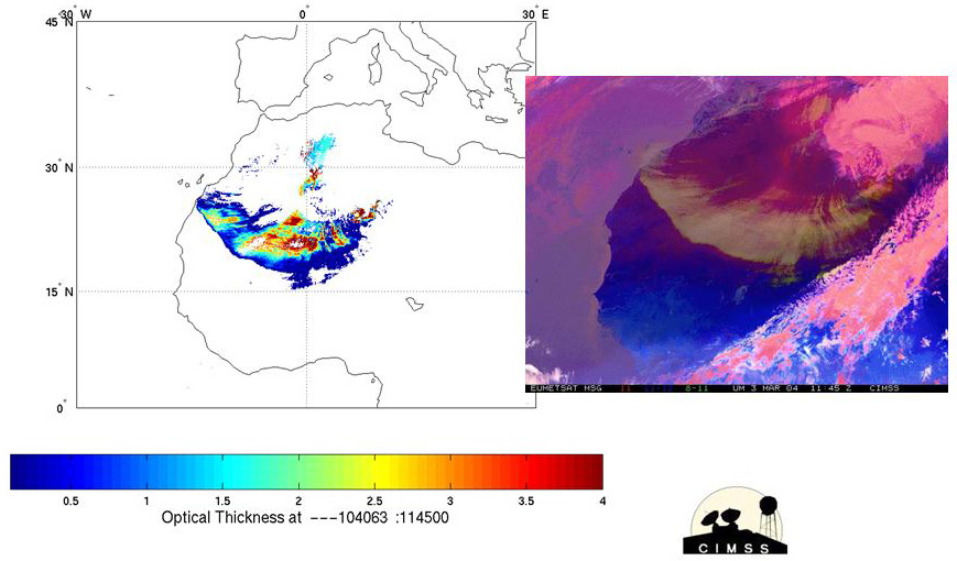
In 2004, using their newly developed retrieval algorithm (formula), Li’s team successfully extracted Saharan dust storm properties, including dust identification, optical thickness, particle size, and density, from the Spinning Enhanced Visible and Infrared Imager (SEVIRI) on the European Meteosat Second Generation (MSG) satellite. The SEVIRI is an advanced satellite imager with thermal infrared (IR) channels specifically selected to detect dust storms—SEVIRI is particularly effective over land surfaces and at night.

The retrieved dust optical thickness (left) and SEVIRI image (right) showing the dust storm (yellow to white) on 03 March 2004 over the Sahara Desert. Image Credit: Jun Li.
High spatial and temporal resolutions make SEVIRI “a very useful instrument for monitoring dust particle size and optical thickness, as well as their changes. Based on these attributes, you can calculate dust intensity,” Li said. But the calculation is still far from perfect–“you have to assume dust height, which is not accurate,” Li said, since dust height is estimated from empirical experiences.
To get more accurate dust information, many scientists have begun using high spectral resolution observations, such as those obtained from the Atmospheric Infrared Sounder (AIRS), an instrument onboard NASA’s Earth Observation System (EOS) Aqua satellite. These remotely sensed, long-wave infrared measurements are used to retrieve dust height and optical depth, but most of the retrieval studies are limited to oceans; there are few on land.
“If [retrieving dust parameters] over oceans, the problem is relatively easy, scientists can assume homogeneous (flat surface) emissivity in their modeling. But over land, you have to select proper emissivity schemes and dust sensitive channels from AIRS, that is difficult,” Li explained. The challenge is that scientists know less about land surface emissivity properties.
Moreover, dust can scatter, absorb and emit thermal radiation, resulting in a complex interaction among dust, solar and terrestrial radiative fields, which makes it difficult to separate the dust contribution from the AIRS radiation signals.
To overcome these difficulties, Li was the first to derive global land surface emissivity datasets over the entire infrared spectra from satellite measurements. In addition to AIRS, the work is based on observations from the Moderate Resolution Imaging Spectroradiometer (MODIS) on the NASA Terra and Aqua satellites. Li’s methodology can also be used to derive global emissivity datasets, with observations from the Infrared Atmospheric Sounding Interferometer (IASI) on the European METOP series and Cross-Track infrared Sounder (CrIS) on the U.S. Suomi NPP satellite.
“The unique part of our research is we’ve developed a good radiative transfer (RT) model along with an inverse model that handles atmospheric and surface properties well for deriving dust properties quantitatively. We can separate the three parts: surface, atmosphere and dust contributions from AIRS radiance observations,” said Li.
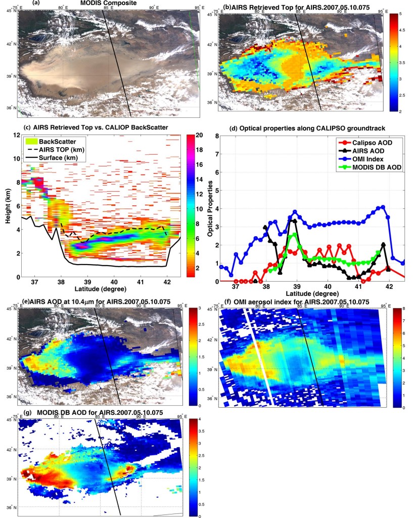
In 2010, Li’s team applied their RT model and retrieval algorithms to dust storms in the Taklimakan Desert in China, successfully extracting the dust height and infrared optical depth from the AIRS long-wave infrared measurements. Because observations from the Cloud-Aerosol Lidar with Orthogonal Polarization Lidar (CALIOP, a NASA satellite instrument) compare favorably with AIRS, they can be used to validate AIRS retrieved products.

(a) MODIS composite image, (b) AIRS retrieved dust top height (km), (c) comparison of AIRS dust top height with the CALIPSO measurements, (d) optical parameters from different measurements (AIRS aerosol optical depth multiplied by four shown in the optical properties along CALIOP track), for the 05/10/2007 dust storm over the Taklimakan Desert. Image Credit: Jun Li.
“The dust properties of East Asia are very interesting to many people but we are the first group to derive dust heights in East Asia from satellite observations,” said Li. With accurate dust height measurements, scientists can use MODIS and SEVIRI observations to more closely derive actual dust parameters. Li attributes the achievement to effective international collaboration.
“We collaborate with scientists from University of Maryland-Baltimore County (UMBC), who have developed a radiative transfer model without dust. Scientists from Japan and Korea provide us with ground observations about dust spectral properties. Without these collaborations, we could not do radiative calculations during dust situations,” Li noted.
Unique to Li’s work is that their models and algorithms can be applied to dust events in global areas, over oceans or land surfaces. “We don’t need to change the code or algorithms, we only need to replace the Saharan or East Asian desert profiles with the region under study,” said Li.
Li noted that the Space Science and Engineering Center (SSEC) at the UW-Madison has accumulated more than ten years of AIRS and MODIS global observational data. Using Li’s methodology, scientists are able to study global dust distribution and trends over this period, resulting in a better understanding of global dust properties and development.
In addition, since dust contamination also negatively affects other atmospheric parameter retrievals and degrades the use of data in weather forecasting, accurate dust storm information will also help scientists pave the way for better forecasts and climate trend studies using satellite data.
According to Li, the powerful multispectral imager (Advanced Baseline Imager (ABI)) hosted on the next generation Geostationary Operational Environmental Satellite (GOES-R) will acquire significantly more information on dust aerosol monitoring than the current imager. Applying Li’s model and algorithms to an advanced geostationary satellite imager like ABI will help scientists to monitor dust evolutions in real time.
But the current algorithm is not perfect. It still has difficulty handling multi-layer dust situations, due to their non-uniform distributions. And, in cloudy skies mixed with dust, it is still difficult to isolate, or separate, dust information.
“Validation is continuous and algorithm refinement and improvement always under way,” said Li.
