Using Satellite Observations of Clouds to Improve Weather Forecasts
By Zhengzheng Zhang
Clouds play a crucial role in regulating the earth’s weather and climate. They adjust the amount of solar radiation that reaches the earth’s surface and affect the surface temperature and moisture. The processes involved in cloud formation also influence large-scale atmospheric circulation and can lead to rapid storm intensification. To accurately forecast the evolving state of the atmosphere, it is important that meteorologists are able to realistically simulate cloud information in weather prediction models.
However, due to their complexity, the evolution of clouds and their interactions with the surrounding atmosphere are often poorly understood by atmospheric scientists, and thus remain a major source of uncertainty in weather forecast models.
One of the first scientists interested in clarifying these uncertainties using satellite observations is Jason Otkin, an atmospheric scientist at the Cooperative Institute for Meteorological Satellite Studies (CIMSS) at the University of Wisconsin-Madison. After devoting many years to studying cloud properties and evolution processes using the Weather Research and Forecasting (WRF) model, he is working to improve the way the WRF model handles clouds. More accurate depictions of clouds will improve forecasts of high-impact weather events.
The WRF is the latest generation of numerical weather prediction (NWP) models, operating in the mesoscale range of weather phenomena with spatial resolution from meters to tens of kilometers. The model employs various schemes to help scientists simulate cloud properties and the evolution of weather events based on different assumptions.
To examine the accuracy of these simulations, Otkin has performed several validation studies, comparing the simulated cloud fields with observation data from geostationary and polar-orbiting satellites. With their high temporal and spatial resolution, geosynchronous satellites are important for model validation because they provide valuable information about cloud and moisture fields.
“I would say, overall, the models do a surprisingly good job at simulating what is a really difficult problem,” Otkin concluded from his studies. He noted that, although there are some differences between the way various schemes simulate the same weather phenomenon, these models generally agree with satellite observations and represent clouds effectively, with the most realistic cloud simulations produced by the more sophisticated schemes.
In recent years, high-resolution simulations from the WRF model have also been used at CIMSS to generate synthetic satellite data for future satellite sensors, such as the Advanced Baseline Imager (ABI) to be launched on the Geostationary Operational Environmental Satellite (GOES)-R in 2015. The high spatial and temporal resolution of the ABI will allow unprecedented observational capabilities over the Western Hemisphere.
In support of the GOES-R mission, CIMSS scientists have made significant contributions to the development of data processing formulas, or satellite retrieval algorithms, for various atmospheric conditions. They are using synthetic satellite data to demonstrate the measurement capabilities of the ABI sensor. The best way to perform these tasks is to have synthetic satellite datasets that can realistically represent the ABI observed cloud structures and spatial distribution of clear and cloudy areas.
As a modeling investigator on the CIMSS GOES-R proxy data team, Otkin has collaborated with his colleagues to generate synthetic satellite datasets by performing high-resolution WRF model simulations covering extensive geographic areas using the NSF-sponsored supercomputing networks.
Because high-resolution model simulations are time-consuming and expensive to perform, many groups within the GOES-R project leverage proxy satellite datasets produced by Otkin’s team that depict the evolution of the atmosphere over one to three day periods.
“It may be expensive to run it [the model simulation] once, but once it is done, everybody can use it,” Otkin said. “You can really start to design and develop processing systems only when you have realistic datasets that you can actually run through them.” The high fidelity of these datasets as demonstrated by validation studies supports a realistic demonstration of GOES-R measurement capabilities and retrieval algorithms.
More than just a demonstration platform, the synthetic satellite datasets also serve as an effective tool for Otkin to study the atmospheric processes that create and characterize severe weather phenomena, such as severe thunderstorms, hurricanes and snow storms.

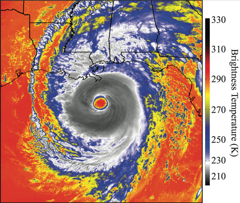
Synthetic satellite imagery of Hurricane Katrina as depicted by ABI 8.5 μm brightness temperatures, computed using data from a high- resolution WRF model simulation at 00 UTC on 29 August 2005. Image credit: Jason Otkin.
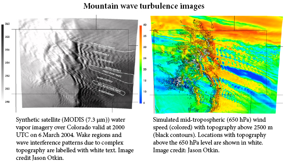
One of his recent studies involves mountain waves over the Colorado Rockies, a disturbance that causes severe air turbulence frequently appearing in pilot reports. Mountain waves can appear as linear waves in satellite water vapor imagery or they can exhibit more complex interference and crossing wave patterns.
“We want to connect what we see in the real satellite imagery to what really happens in the atmosphere. The best way to do it is to use the WRF simulation,” said Otkin. He explained that the real satellite imagery only tells the external features of mountain waves, while the synthetic satellite imagery combined with the WRF model simulation output reveals detailed information about the vertical motion within the mountain waves. By comparing the real and synthetic imagery, Otkin gained insight into the entire process of air turbulence development, enabling him to infer the height and vertical depth of the mountain waves.
“It is important to say these mountain waves are at 3km, 5km or 10km above the surface,” said Otkin. “You really want to avoid flying through the mountain waves, because they can cause a lot of turbulence.”
Given that the synthetic satellite imagery is based on the future GOES-R ABI spectral bands, Otkin’s study also demonstrated the future sensor’s unique ability to observe mountain waves.
Similar to many other meteorologists, Otkin’s ultimate goal is to improve the accuracy of severe weather forecasts, especially short-range forecasts (0-12 hours). Using observed satellite data as an initial basis to run model forecasts is not new (the technique is called data assimilation), but due to the challenge of assimilating cloud data, most scientists focus on assimilating observations in clear sky conditions. Otkin’s approach, however, focuses on cloudy skies.
“You can really make important improvements to the model forecast accuracy if you can assimilate these cloud observations,” Otkin noted, since almost all severe weather events occur in cloudy regions.
In a recent study, Otkin compared the conventional forecast of a blizzard impacting Oklahoma and Kansas in 2009 with the WRF model forecast that assimilated cloud data. The WRF model effectively matched the actual snowfall of 10 inches for the heavy snow area–more accurate than the conventional snow prediction of four inches.
Using data assimilation techniques and the WRF model, the GOES-R data assimilation team has been conducting experiments to examine the potential ability of ABI clear and cloudy-sky observations to improve forecasts of high impact weather events.
Running the numerical simulations and processing the data has generated about 15 terabytes of data. “You have to be very good at handling large datasets,” Otkin said. The most challenging part is not the high volume of data, but rather, how to handle the uncertainties in the numerical simulation process.
For example, when generating synthetic satellite data, “you have to use a forward radiative transfer (RT) model, which converts the [WRF] model data to what the satellite would actually observe. That is very challenging, particularly [with respect] to clouds,” Otkin said, since the forward RT model is still early in its development and also needs more extensive validation.
“As I do validation studies, I am also validating the forward RT model along with the WRF model, it is hard to separate them,” said Otkin. His research will continue to focus on clarifying the uncertainties in the latest forecast models, the next step in achieving more accurate weather forecasts.

