Monthly News Summary – May 1998
Light Maps the Earth’s Mysteries
by Terri Gregory, SSEC Public Information Specialist
Photonics Spectra magazine recently featured a UW-Madison lidar system in “Lidar Helps Unravel Environmental Mysteries.” The April 1998 issue of the magazine, which covers optics technology, compared five different light detection and ranging (lidar) systems from around the world. All measure complex environmental processes, from mapping changing depths along a jagged Baltic coastline to locating buried toxic waste.
Volume Imaging Lidar (VIL), the UW system featured, measures the three dimensional structure of the atmosphere over time. Or as SSEC scientist Ed Eloranta puts it, “We make what is invisible, visible.” Lidar instruments can “see” things like practically invisible clouds, thermal plumes, tiny particles of dust, trace gases, and microscopic water vapor droplets.
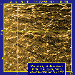 |
This lidar image shows rings of clouds caused by the formation of open-cell convection. As the outer edges of a column of air move upward, the center moves downward forming the open rings at the center of the clouds. On January 10, 1998, open-cell convection was forming just off Lake Michigan’s shore in the boundary layer, where the Earth’s surface (in this case, the lake) directly influences the atmosphere. The diagonal streaks crossing the image are caused by steam fog rising off the lake and attenuating the lidar signal. |
The article includes images gathered with both the VIL and High Spectral Resolution Lidar (HSRL) systems as well as a picture of the VIL system as it was used during this winter’s Lake-Induced Convection Experiment. The experiment studied the lowest level of the atmosphere over Lake Michigan. By using the lake’s relatively warm water as a sort of laboratory setting, scientists studied “the transfer of heat, water vapor and wind stress by convective motions” near the Earth’s surface.
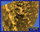 |
Light snow falling from thin stratocumulus clouds is carried by winds from two slightly different directions. The winds converge in the bright line that can be seen running from top to bottom at the left side of the image. SSEC’s Volume Imaging Lidar system collected this image on December 20,1997, by taking a horizontal scan a few meters above the Earth’s surface. |
Eloranta leads the UW lidar group composed of SSEC employees and graduate students in the Department of Atmospheric and Oceanic Sciences. The group’s VIL system includes hardware elements produced by a variety of specialist manufacturers–an interference filter from Corion in Massachusetts, optical components from Arizona’s Star Optical, and a photodiode from Optoelectronics Canada, Quebec.
For more information, follow the links below.
In Print
Refrigerators and Hurricanes
For More Information
An edited version of Russell Hall’s Soundings article on the Adiabatic Demagnetization Refrigerator appeared in Wisconsin Week(April 15) under the name “Refrigerators in Space.” You can find the unadulterated original on SSEC’s Media page.
SSEC’s three-channel color-composite image of Hurricane Emily is reproduced in Space News (March 30-April 5) in the “Global Snapshot.” NOAA is credited for the AVHRR data used in the image. You can find this and other hurricane images on the SSEC and CIMSS Web sites. All images are produced by SSEC, unless otherwise noted. A NOAA logo is shown in the corner of every image not processed. Imagery on the CIMSS Web site is the result of collaboration between researchers in NOAA’s Satellite Applications Branch and SSEC.
ITT Industries used SSEC’s colorful global montage on a promotional postcard handed out at January’s American Meteorological Society Conference. Fully crediting SSEC for the picture, ITT’s Aerospace/Communications Division noted that they made two instruments whose data is used in the montage-the Advanced Very High Resolution Radiometer on NOAA’s Polar Operational Environmental Satellites and the Imager on NOAA’s Geostationary Operational Environmental Satellites.
Biomass Burning *web-archived version*
Brazil’s Visions publication contacted Elaine Prins for information about recent CIMSS research on biomass burning in South America. Elaine gave the reporter an overview of results for the 1995 and 1997 fire seasons.
On the Air
For More Information
NBC-TV4 in Washington, DC, has been using SSEC’s rotating globe movie on occasional evening telecasts. McIDAS Operations manager Jerry Robaidek reproportioned the animation to better fit the television screen. That annoying black “tear” across the Pacific has been fixed, but the fix now causes slight distortion near New Zealand. Even before SSEC sent him the new and improved globe, producer Bob Ryan called the globe “a wonderful and useful image.” Last month, we reported that WISC-TV viewers saw brown and red rain and called us to find out why. In the News said that the cause was uplifted sands. But it was soils that were lifted, not sand. Senior scientist Dave Martin notes, “a strong wind can levitate sand too, but I think only a tornado could raise sand to cloud levels.” The CBS Evening News featured Colorado State University meteorologist William Gray’s annual hurricane forecast on April 7. In the same piece they also showed the Tropical Prediction Center (formerly the National Hurricane Center). In both cases McIDAS was running in the background.
*web-archived version*
A videotape produced by the San Diego Supercomputing Center (SDSC) uses SSEC GOES-9 infrared images from the winter of 1997-98. The SDSC tape illustrates El Niño characteristics by showing wind speeds for the 1982-83 El Niño, the 1988-89 La Niña period, and spring of 1997.
Teaching and Outreach
For More Information
SSEC’s Outreach Office recently received an Eisenhower grant. Sanjay Limaye and Rose Pertzborn’s proposal for the Wisconsin Initiative for Space Education was one of 38 to be submitted to Wisconsin’s reviewers, who represented public and private higher education organizations, as well as nonprofits and the Department of Public Instruction. The Eisenhower Professional Development Program is funded through Title II of the Improving America’s Schools Act of 1994.
Software and the ‘Net
For More Information
Express Technologies will use a new projection of SSEC’s global montage and sea surface temperature images in World Watch, a software program that displays time across the world’s time zones. Choosing an SSEC backdrop displays cloud conditions or ocean temperatures in addition to time zones.
A variety of Web sites link to the SSEC Web site, usually for satellite imagery. Joshua Ward uses SSEC’s sea surface temperature image on his Solar System Web site to illustrate El Niño. The on-line version of USA Today links to CIMSS and SSEC pages in their Satellite Index page. In addition, USA Today maintains a weather resource page that includes many useful and interesting weather facts. A WebTV user includes a background of clouds and SSEC’s satellite images on his site.Direct comments, questions, and information about other SSEC media appearances to Terri Gregory, SSEC’s Public Information Specialist. For information about past media appearances, visit SSEC In the News page.