Monthly News Summary – September 2003
This issue of SSEC In the News covers news and research results primarily from August 2003. Use images freely with credit to the Space Science and Engineering Center, University of Wisconsin–Madison, but please notify Terri Gregory.
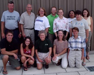
The Wisconsin Weather Stories project has gotten off to a fine start. The four teachers and an alternate picked to work on the project attended an orientation workshop in August at UW–Madison’s SSEC. They were joined by senior undergraduates in atmospheric science and folklore who, as part of their course requirements, are acting as technical consultants in science and folklore. Teachers and consultants together will draw from local stories and meteorological data to create a curriculum that meets academic standards in Science, English Language Arts, and the Social Studies. At the end of the project, funded by the Baldwin Wisconsin Idea Endowment, they will post their curriculum on three Web sites, available for free use by other teachers and anyone else interested in weather lore. To judge from the pervasiveness of weather terms and stories in the language, at least in Wisconsin, the site will be popular. Not only are lesson plans posted on the Weather Stories Web site, but some fantastic weather narratives are, too. The fall semester has just started; teachers have only begun to complete lesson plans. As the project progresses, much more will be added, so keep in touch.
The Wisconsin State Journal’s higher education reporter Karen Rivedal joined project participants during their orientation and noted in her August 14 piece that telling weather stories ought to include some key steps followed by scientists, “such as observation, analysis, and hypothesis or prediction.” University Communications science editor Terry Devitt issued a news release explaining the project in more depth on September 9. Steve Ackerman, a project leader who directs the university’s Cooperative Institute for Meteorological Satellite Studies and teaches meteorology, was interviewed by WIBA Radio’s news director Michael King on September 10. The project’s story also appeared in the Wisconsin Week Wire and in the campus newspaper, Wisconsin Week, for September 10.
The project will run from May 2003 through June 2004. Teachers selected for the program are Russ Bailey who teaches 7th grade science at Northwestern Middle School in Poplar, Wisconsin; Teyulelu Cornelius, a teacher in the Gifted and Talented program at Oneida Nation Schools in Oneida; Mary Kornely, a 4th grade teacher in the Denmark Elementary School; and Karyl Rosenberg who teaches high school science at Nicolet High School in Glendale. Alternate teacher Mary Jo Fuhry teaches elementary science in Milwaukee’s Indian Community School. UW–Madison students involved in the project are Louie Holwerk, Holly DeRose, Kris Karnauskas, Claire Schmidt, and Jamie Yuenger. Besides Steve Ackerman, project coordinators are project manager Margaret Mooney who is a meteorologist and outreach specialist with SSEC’s Office of Space Science Education, James Leary who directs UW–Madison’s Folklore Program and is codirector of the Center for the Study of Upper Midwestern Cultures and Professor of Scandinavian Studies, and Anne Pryor who is Folk Arts Education Specialist for the Wisconsin Arts Board.
Watch the SSEC Features page for a story featuring experiences of students in the Weather Stories Project. For more information, contact Anne Pryor, or Steve Ackerman.
For More Information
Data and Imagery
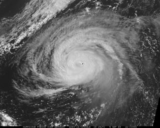
SSEC’s Web site for viewing MODIS data from NASA’s Terra satellite is once again available. Recent images of note include Hurricane Fabian approaching Bermuda (September 5), fires and smoke in Manitoba and Ontario, Canada (August 19 and July 22); and contrails over the Gulf of St. Lawrence, Canada (August 21).
Global Montage—Craig Dreman, a California ecologist, uses SSEC’s global montage to show rainfall and its lack on his Web site devoted to global warming. The image and link to the latest is almost half down in the page.
Real-time Imagery—Ronald Schleyer, of Eugene, Oregon, has been viewing on the SSEC Web site a forest fire that he can almost see from his home. He thanked us and “the great State of Wisconsin for sponsoring and updating this beautifully designed web site for viewing the Earth’s atmosphere and surface at various wavelengths, points of view, angles, and times, including real-time views.” He finds it “amazing that the tracks of smoke from the fire are clearly visible from 23,000 miles in space,” about where the GOES orbits above the earth. More poetically, he says, “one sees the smoke moving northwest (as of a half-hour ago) as if in a motion picture filmed by God!” SSEC serves both geostationary and polar-orbiting satellite imagery in real time.
Blackout—Imagery from the U.S. Air Force’s Defense Meteorological Satellite Program showed the effects of August’s massive blackout in the eastern U.S. SSEC put The Times of London in touch with the Air Force Weather Agency’s John Zapotocny, an alumnus of UW–Madison’s Department of Atmospheric and Oceanic Sciences, who provided DMSP F-15 nighttime visual images. The ABC Nightly News with Peter Jennings used the images on Friday evening’s broadcast. The DMSP satellite is the only weather satellite that picks up the light from city lighting as well as lightning. The DMSP public archive resided at SSEC from the late 1970s through 1983, when it was moved to the National Geophysical Data Center in Boulder, Colorado.
Experiments and Meetings
Data-mining Workshop—Jeff Key and Gary Wade (both with NOAA/NESDIS stationed at SSEC) organized a workshop held August 20-21 at SSEC to begin planning for and developing new satellite products and presentation formats for current and future satellite data for weather forecasters in the field. Workshop organizers sought to identify the most effective ways to present essential information to forecasters. Personnel from the National Weather Service, NESDIS, the Army Research Lab, and three universities participated. A report with a summary and recommendations will be available in the near future. Watch this space for more.
Aurora—UW–Madison, including SSEC, has become an associate member of Aurora, an international partnership of public agencies who work together in research activities in the area of Road Weather Information Systems technology. The group includes a number of U.S., Canadian and European agencies, including several U.S. state Departments of Transportation. Scott Lindstrom is SSEC’s representative to Aurora, which also works with the College of Engineering, who have recently established a new traffic lab.
Neutrino News
Discover Magazine has published a short piece about the neutrino sky map, devised by Francis Halzen of the Antarctic Astronomy and Astrophysics Research Institute (A3RI), in its October issue (p.10). The Web site currently (September 11) has posted the September 2003 issue.
The innovations-report, the forum for Science, Industry and Business, has published news of the neutrino map and telescope. The report is published by IDEA TV in Bad Homburg, Germany.
Journalist Lucia Simion writes about IceCube in Italy’s Panorama magazine (August 21). This Italian weekly is somewhat like Time magazine.
Tropical Cyclones
Fast—Derrick Herndon, a member of SSEC’s CIMSS Tropical Cyclones group, appeared on WISC-TV on Saturday September 6. Interviewed as Hurricane Fabian passed over Bermuda, Herndon showed many aspects of the group’s hurricane research. The reporter noted how quickly Tropical Cyclone products are made from satellite imagery. It takes only about an hour to process an image and serve it over the Web where it is accessible to anyone.
 |
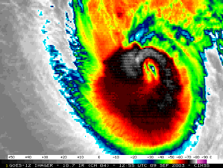
The dot in the center of the image is Bermuda. Three images of Hurricane Fabian are on theTropical Cyclones Web site, beneath Storm Coverage under Cool Image(S) Of The Week. |
Useful—In a recent email to Chris Velden, who leads CIMSS’s Tropical Cyclones group, Jim Weyman expressed appreciation for the group’s wind shear products. Weyman directs the Central Pacific Hurricane Center, Honolulu, where meteorologists forecast weather, including tropical cyclones, for Hawaii and the entire region. He said the products are used extensively, and that they receive “a lot of kudos from state and county civil defense officials and the media on the forecast.”
Amazing—Chris Fogarty, a research meteorologist in Dalhousie University, Halifax, Nova Scotia saw rapid-scan images of Hurricane Isabel posted on the GOES Gallery and said, “Those images are FANTASTIC! In the visible loop you can see low-level clouds whipping by, moving northward. Might be stratocumulus in the eye.”
|
Weather Research
Simulating Next-generation GOES Imagery—To simulate infrared channels on the next series of Geostationary Operational Environmental Satellite (GOES) imagers, the Advanced Baseline Imager (ABI), SSEC is providing an in-house beta broadcast of Atmospheric InfraRed Sounder (AIRS) data. These data are from the instrument on NASA’s Aqua satellite. The spatial resolution of the infrared ABI bands is much finer than the AIRS data and will not be simulated. The images and brightness temperatures files are updated daily at 2300 UTC.
Studying Amazon Air Quality—Elaine Prins (NOAA, working with SSEC) provided GOES-8 Wildfire Automated Biomass Burning Algorithm (WF_ABBA) fire products for South America to S. Nandi of NOAA’s National Center for Atmospheric Research. Nandi will assimilate the fire products into the EPA’s Community Multiscale Air Quality (CMAQ) Model to study regional air quality in the Amazon Basin to support the SMOCC (SMOke aerosols, Clouds, rainfall and Climate) research program. SMOCC is part of the Large-Scale Atmosphere-Biosphere Experiment in Amazonia (LBA). The overall goal of SMOCC is to investigate connections between biomass burning aerosols and regional and global climate. CIMSS’s GOES biomass burning monitoring team is collaborating with S. Nandi to properly assimilate the GOES fire products into the CMAQ model.
Papers, Presentations
Where SSEC staff or students are first through third authors, or, if not, the contributions are substantial.
In July 2003, the World Meteorological Organization Bulletin published “A Survey of Tropical Cyclone Forecast Centres – Uses and Needs of Satellite Data.” The paper, by Russell Elsberry and Chris Velden, resulted from a survey conducted at the International Workshop on Tropical Cyclones (TC) held in Cairns, Australia in December 2002. The survey documented the current most important applications and widely used satellite products at global TC forecast centers, and polled the TC forecasters on user needs, including desirable satellite enhancements and products.
The Journal of Applied Meteorology (JAM) has published (vol. 42, no. 8, 2003) “Operational Retrieval of Atmospheric Temperature, Moisture, and Ozone from MODIS Infrared Radiances,” by Suzanne Seemann, Jun Li, Paul Menzel, and Liam Gumley.
JAM has accepted “Assimilating GOES Brightness Temperatures. Part 1: Upper Tropospheric Moisture” by William Raymond, Gary Wade, Thomas Zapotocny, et al. Wade (NOAA, at SSEC) and Zapotocny (SSEC) completed the paper after Dr. Raymond’s passing in February 2003.
The Journal of Geophysical Research has published (vol. 108, no. D13, 2003) an issue on SAFARI 2000, the Southern African Regional Science Initiative. SSEC researchers helped write three of the papers.
- Remote Sensing of Smoke, Land, and Clouds from the NASA ER-2 during SAFARI 2000—Key author is Michael King (Goddard Space Flight Center). SSEC authors are Christopher Moeller and Henry Revercomb. Other authors are Steven Platnick and Allen Chu.
- Evaluation of MODIS thermal IR and L1B radiances during SAFARI 2000, by SSEC authors Christopher Moeller, Henry Revercomb, Steven Ackerman, Paul Menzel (NOAA/NESDIS, stationed at SSEC), and Robert Knuteson
- Tropospheric carbon monoxide measurements from the Scanning High-Resolution Interferometer Sounder on 7 September 2000 in southern Africa during SAFARI 2000, by W. McMillan, M. McCourt, H. Revercomb (SSEC), R. Knuteson (SSEC), T. Christian, B. Doddridge, P. Hobbs, J. Lukovich, P. Novelli, S. Piketh, L. Sparling, D. Stein, R. Swap, and R. Yokelson
The Proceedings of the Conference on Polar Meteorology and Oceanography, 7th, and Joint Symposium on High-latitude Climate Variations, held in Hyannis, MA, May 12-16, 2003published by the American Meteorological Society includes several papers by SSEC researchers and NOAA/NESDIS researchers stationed at SSEC.
- Observations of Antarctic Fog Particles by Matthew Lazzara (SSEC), Pao Wang (AOS), and Charles Stearns (SSEC)
- 10 years of Antarctic Composite Images by M. Lazzara, C. Stearns, Jessica Staude, and Shelley Knuth, all with SSEC
- An Antarctic Cloud Mass Transport Climatology Overview by J. Staude, C. Stearns, M. Lazarra, Linda Keller (AOS), and Steven Ackerman
- Recent Arctic Climate Trends Observed from Space and the Cloud-radiation Feedback by Xuanji Wang (CIMSS) and Jeffrey Key (NOAA/NESDIS, at SSEC)
- Study of Clear Sky, Low-level Atmospheric Temperature Inversions Using Satellite Data by Yinghui Liu (CIMSS) and J. Key
Education, Outreach
Planet Observers Meet—Sanjay Limaye, SSEC scientist and director of its Office of Space Science Education, was a featured speaker at this year’s meeting of the Association of Lunar and Planetary Observers. The meeting was held in August in Boardman, Ohio. Limaye spoke about Neptune.
Thanks to Rob Gutro for content, Brian Kayon for technical support, and to Jeff Key, Steve Ackerman and the Wisconsin Weather Stories project consultants.


