Monthly News Summary – December 2003
Happy Winter Solstice!
This issue of SSEC In the News covers news and research results from October and November 2003. Use images freely with credit to the Space Science and Engineering Center, University of Wisconsin–Madison, but please notifySSEC’s Public Information Officer.
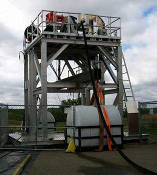
As it has annually for almost ten years, SSEC has strung lights around its 24-foot dish antennas atop the roof of its home, the Atmospheric, Oceanic and Space Sciences building. When lit, the lights can be seen from across Lake Monona. If you’re in the area, and you need uplifting in this cold, bleak winter, turn your face toward the south campus and scan the rooftops for this bit of cheer.
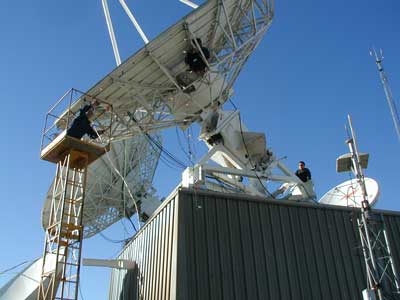 |
On the elevator is antenna crew chief Dave Jones, Will Robus is on the antenna. Kevin Ma assists on the penthouse roof. Building manager JoAnn Banks took the picture. |
Antarctica
Eclipse—A solar eclipse occurred Sunday, November 23, 2003, the first in more than a hundred years over Antarctica. SSEC’s Antarctic Meteorological Research Center (AMRC), the only group that provides Antarctic composite images from satellite data, had hoped the eclipse would be visible in composites or other imagery. For the eclipse, the AMRC began to produce composites using visible (what the eye can see) data; previously, all composites were made using imagery in wavelengths sensitive to temperature (infrared) and water vapor. However, visible data is available over the continent only sporadically, and the Sunday of the eclipse was no exception. However, the NOAA group stationed at SSEC—the Advanced Satellite Products Team—helped make data available from the Moderate Resolution Imaging Spectroradiometer (MODIS) instrument on NASA’s Terra satellite for posting on the AMRC Web site. For polar research, Jeff Key, ASPT leader, routinely receives MODIS data over both Arctic and Antarctic regions in near real-time via the Internet from a NOAA computer located at Goddard Space Flight Center near Washington, D.C.
The AMRC also experimented with Automatic Weather Station data during the time and in the path of the eclipse to see if the shadow would cause the temperature to decrease appreciably. Thus far, the data show at most a small change.
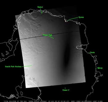 |
This visible MODIS image (channel 1) shows the arc of the eclipse shadow. You can see the TransAntarctic Mountains at the lower left of this black and white image. Note that they’re not all white; some of them don’t have snow on all sides. |
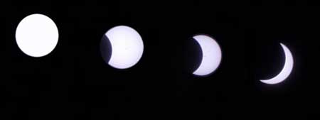
NASA’s Earth Observing site provided a true-color image. From the ground, Ethan Dicks took his own composite of eclipse images. Ethan works at the South Pole with the Antarctic Muon and Neutrino Detector Array (AMANDA), a project within the UW–Madison’s Antarctic Astronomy and Astrophysics Research Institute (A3RI) and the precursor to IceCube. He reported that, although the day was beautiful, “the wind chill was -66F and we set a low-temp record for the day.”
Icebergs—A Terra MODIS image, provided by SSEC’s Antarctic Meteorological Research Center, showed the breakup of B-15A on October 3. On October 20, Space Daily covered the breakup, based on a release from UW–Madison’s Communications Office. Wisconsin Week published the satellite image on October 22. Yahoo!News linked to the AMRC iceberg site from an article about the iceberg breakup from the Canadian Press reported from New Zealand. The AMRC was among the first groups to note the breakup of the giant iceberg, formerly about 100 miles long. Since the breakup, new satellite imagery shows pieces of the original iceberg (now B-15A, B-15J, and C-16) moving farther apart, possibly due to a low pressure system in the Ross Sea. See the image marked November 28.
Data, Imagery, Software
The Schwerdtfeger Library at SSEC maintains a large collection of photomicrographs taken by pioneering ice crystal photographer Wilson Bentley. In its Winter 2003 issue, On Wisconsin, UW–Madison’s alumni magazine, tells how the collection came to the Library. According to librarian Jean Phillips, “Bentley was adamant that his pioneering work belonged to the world, not to him or Vermont, so he made his pictures available to as many scientists as possible.” One of those was physics professor Benjamin Snow, who collected about 1200 of them to use in lectures. When Snow retired, the Meteorology Department (now the Department of Atmospheric and Oceanic Sciences, or AOS), acquired the collection and it was passed on to The Schwerdtfeger Library as were the contents of the Meteorology Reading Room, in the same building as SSEC. In 2002, Phillips had the ice-crystal collection digitized and made available to the public. It is publicly available on the Library Web site.
GIS—SSEC research was represented in the November 19 GIS Day exhibits on campus. At UW–Madison’s Memorial Union, local GIS organizations exhibited their wares and talked about their research. Organizations included local branches from State and federal agencies, such as the Department of National Resources and the U.S. Geological Survey. UW–Madison’s Environmental Remote Sensing Center gave ample credit to SSEC for its direct broadcast of MODIS data from NASA research satellites Aqua and Terra. The ERSC serves MODIS data over Wisconsin in a user-friendly format on their Web site. SSEC contributes to the Precision Agricultural-Landscape Modeling System (PALMS) through the research of Christine Molling, who works on the model with researchers in the Colleges of Engineering and Agricultural and Life Sciences. PALMS is a GIS-based model for agricultural decision making, and, according to Molling, “PALMS is playing a major role in the Wisconsin Buffer Initiative (WBI), a group which has been tasked by the State of Wisconsin to come up with policy recommendations for the State’s Buffer Standards that are scientifically defensible, practical for landowners, fiscally responsible, and supported by all WBI constituents.”
Oceanographic Data and Information Exchange—CIMSS’ Tom Whittaker and Steve Ackerman have provided teaching applets (small but powerful Java software applications with instructions) to the International Oceanographic Data and Information Exchange, a resource for managers of oceanographic data centers. Although labeled ”Under construction,” the applets are available for use in the teacher resource kit.
Field Experiments and Meetings
SPIE—CIMSS scientist Allen Huang will chair jointly with NOAA’s Hal Bloom a newly established conference within the annual meeting of the Society of Photo-optical Instrumentation Engineers. The Atmospheric and Environmental Remote Sensing Data Processing and Utilization: an End-to-End System Perspective will be held concurrently with SPIE’s 49th Annual Meeting, August 2–6, 2004 in Denver’s Colorado Convention Center. This conference recognizes that those who use remote sensing data have increasingly sophisticated needs and the conference committee hopes for papers that address those needs. The committee membership draws on expertise in the satellite data utilization community, most long-time collaborators with SSEC’s CIMSS. They include Gerald Dittberner (NOAA), James Dodge (NASA), Jeff Hawkins (Naval Research Lab), Mervyn Lynch (Curtin University of Technology in Australia), William L. Smith, Jr. (NASA Langley Research Center), and others. Committee members from UW–Madison are, beside Huang, John Mecikalski and Chris Velden (with SSEC) and Tim Schmit (NOAA, at SSEC).
ITOVS— The International Working Group for use of the TIROS Operational Vertical Sounder held its thirteenth Conference in Ste. Adele, Quebec, Canada from October 29 to November 4. Scientists from 20 countries and from all agencies who provide weather satellites attended the meeting. Key topics included initial research with the newly launched Atmospheric Infrared Sounder instrument, weather and climate applications with the Advanced TIROS Operational Vertical Sounder, and the impact of satellite data on numerical weather prediction. Several modeling centers reported that satellite data now has the greatest impact of all input, primarily from the Advanced Microwave Sounding Unit-A. Scientists in SSEC’s CIMSS and NOAA scientists stationed at SSEC presented 10 oral talks and 11 posters.
Ice Coring and Drilling
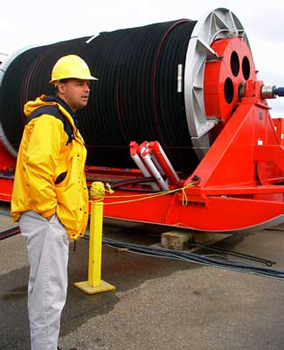
IceCube—The Antarctic Sun, official newspaper for the U.S. in Antarctica, featured IceCube in its November 2 issue, the second issue of the southern summer season. South Pole correspondent Tracy Sheeley notes that preparation for IceCube, a major project for SSEC’s Ice Coring and Drilling Services, begins this year at the South Pole. Currently, a giant hose reel and all supporting equipment and buildings are assembled on the grounds of UW–Madison’s Physical Sciences Lab near Stoughton, WI, getting ready for shipment to Antarctica. Program Manager Mark Mulligan noted that, to find out more about the weather they’d face, ICDS used data from UW’s Automatic Weather Station program and Antarctic Meteorological Research Center, which have weather data holdings since 1956. At the South Pole, all 80 IceCube holes have been surveyed and staked out, according to IceCube implementation manager Robert Morse.
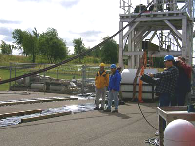 |
From top left: Mark Mulligan, project manager, stands before the hot water hose drill on its Bucky Badger red sled; a pumping tower looms over operations; engineers and videographer are shown for scale.(Photos, T.Gregory) |
Planets
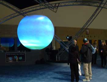
Neptune on Sphere—SSEC planetary scientist Sanjay Limaye took images of Neptune to the Minnesota Science Museum in November where they were finally projected onto a medium worthy of them. In April 2002, Larry Sromovsky, Pat Fry and Sanjay Limaye (all of SSEC) and Kevin Baines (Jet Propulsion Lab) released images of Neptune taken with the Hubble Space Telescope showing increased brightness in Neptune’s southern hemisphere, a probable sign that the planet not only had seasons, but that spring had come to the planet’s south. In November 2003, the images were displayed on NOAA’s Science on a Sphere globe at the annual meeting of the Association of Science-Technology Centers. Four projectors shine images onto the large sphere, produced by NOAA’s Forecast Systems Laboratory.
Tropical Cyclones
On Wisconsin (Winter 2003) noted that UW–Madison’s tropical cyclones research team monitored the progress of Hurricane Isabel. The magazine noted correctly that “the team created a series of images based on real-time satellite data, which were used by the National Hurricane Center, the Weather Channel, and other storm trackers.”
Weather Events
In November, members of SSEC’s McIDAS team provided information for the weather record books. Gary Cannalte, WISC-TV Chief Meteorologist, needed to answer a question in his column, “Hey, Gary!” in Madison’s Wisconsin State Journal. SSEC researcher Dave Santek provided record high and low temperatures set on the same day in not only one but three U.S. cities. On November 11, 1911, Oklahoma City had a record high of 83 and set a record low of 17 “just before midnight after passage of a powerful cold front.” Record high/low temperature combos have also been set in Sioux City, Iowa (91/33, May 16, 1997) and Melbourne, Florida (97/68, May 22, 1998).
SSEC researcher Scott Lindstrom provided these Wisconsin weather record tidbits:
- Tuesday, November 4, was the third day in a row with record rainfall in Madison, Wisconsin:
- 1.41″ on Sunday, November 2 (old record was 1.22″ in 1961),
- 1.96″ on Monday, November 3 (old record, 1.50″ in 1935),
- at least 1.43″ Tuesday, November 4 (old record, 1.21″ 1959).
- That was a total of just under 5″ over three days, putting November 2003 in fifth place for wettest Novembers.
- November 2003 was also the first time when more than an inch of rain fell for each of three consecutive days in Madison, for any month.
Weather Research
Numerical Modeling—Adding GOES-12 sounder products produced a more accurate forecast than a forecast from a model run that did not use them. CIMSS’ real-time CRAS (CIMSS Regional Assimilation System) forecast generated on November 18 at 00:00 UTC showed a single large area of convection in western Missouri 13 hours into the forecast. When cloud-top pressure and three-layer precipitable water from the GOES-12 sounder were included in the model initialization, the CRAS generated two areas of convection, which were verified using a composite radar intensity. Bob Aune (NOAA, at SSEC, and CRAS author) believed that the improved forecast resulted from changes in the horizontal gradients of water vapor and cloud water that were generated when the single field-of-view GOES sounder information was included.
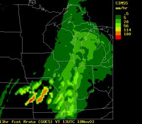 |
CRAS forecast valid for 13:00 UTC November 18, 2003 with GOES sounder information. |
Calibration Studies—All scientists want their instruments to be precisely calibrated. Often, assuring this is done is a nontrivial task, particularly once an instrument is launched into orbit around the earth. A different set of constraints operates in space from those on earth. Researchers at SSEC, its Cooperative Institute for Meteorological Satellite Studies, and the NOAA group stationed at SSEC called the Advanced Satellite Products Team (ASPT) are particularly adept at this complicated task. Andy Heidinger (NOAA, at SSEC) is working with A. Jelenak of NOAA’s Office of Research and Applications, the ASPT parent organization, to develop post-launch calibrations that are more accurate but also provide consistent results for all Advanced Very High Resolution Radiometers. This instrument, or AVHRR, is the imager on NOAA’s polar-orbiting satellite and the one that scientists depend on most for high-resolution Earth images. Previous methods for post-launch calibration of AVHRR reflectance channels involved calibrating each satellite independently. As part of the AVHRR reprocessing initiative, Jelenak and Heidinger are rederiving calibrations, a method that uses the relative ratio of nadir observations coincident in time and space from two AVHRRs, thereby making the calibration of one AVHRR dependent on those of other AVHRRs. Most importantly, the derived (preliminary) calibration curves from this method match both the observed calibration slopes and their intersatellite ratios.
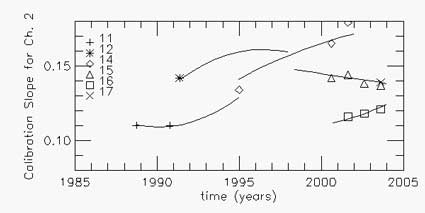 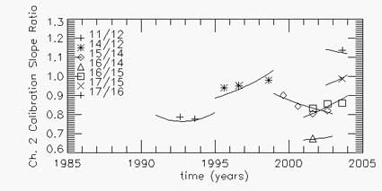 |
Results for the channel 2 calibration for NOAA-11, -12, -14, -15, -16 and -17. The calibration-slope data points are derived from NASA’s Moderate Resolution Imaging Spectroradiometer after the year 2000; the data points before 2000 are from aircraft or other well-validated sources. |
Papers, Presentations
Where SSEC staff or students are first through third authors, or, if not, the contributions are substantial.
“Mathematical aspects of the meteorological processing of infrared spectral measurements from the GOES sounder, part III: Emissivity estimation in solving the inverse problem of atmospheric remote sensing,” by Youri Plokhenko and W. Paul Menzel, was published in the Journal of Applied Meteorology, vol. 42, no.11, 2003.
Presentations at American Geophysical Union, December 2003
- Land Surface Product Validation Using the DOE ARM Southern Great Plains Site, Bob Knuteson, Hank Revercomb, Dave Tobin, Brian Osborne.
- Implementing GLOBE in Wisconsin, Sanjay Limaye and Rose Pertzborn.
- Workshop on Teaching Astronomy Space Science at High School and Middle School Level, Rose Pertzborn and Sanjay Limaye.
- Example MODIS Global Cloud Optical and Microphysical Properties: Comparisons Between Terra and Aqua, P. A. Hubanks (SSAI), S. Platnick (NASA/Goddard Space Flight Center), M. D. King (NASA/Goddard Space Flight Center), S. A. Ackerman (UW-Madison/CIMSS), R. A. Frey (UW-Madison/CIMSS)
- Giant Tabular Icebergs as Surrogate Ice Shelves in Field Studies of Antarctica’s Response to Environmental Warming, D. R. MacAyeal (U. Chicago), J. Thom (SSEC), A. Bliss (U. California, Berkeley).
Presentations to be given at the American Meteorological Society Annual Meeting in Seattle, January 2004
- “An Objective Nowcasting Tool That Incorporates Geostationary Satellite Measurements,” submitted to the Symposium on Planning, Nowcasting, and Forecasting in the Urban Zone. The authors are R. M. Aune (NOAA, at SSEC) and R. Petersen (SSEC, formerly NOAA).
- “Study of the Advanced Baseline Imager (ABI) on the GOES-R and Beyond,” to the 20th International Conference on Interactive Information and Processing Systems (IIPS) for Meteorology, Oceanography, and Hydrology. Authors are T. J. Schmit (NOAA, at SSEC); J. Li, M. M. Gunshor, C. Schmidt (all with SSEC); P. Menzel (NOAA, at SSEC); and J. J. Gurka, and J. M. Sieglaff (NOAA).
- “Utilizing MODIS (MODerate-resolution Imaging Spectroradiometer) Satellite Observations to Monitor and Analyze A Fine Particulate Matter, PM2.5, Transport Event” and “Utilizing MODIS Satellite Observations in Near-Real-Time to Improve AIRNow Next Day Forecast of Fine Particulate Matter, PM2.5” to Sixth Conference on Atmospheric Chemistry: Air Quality in Megacities. Both papers include applications of GOES Wildfire Automated Biomass Burning Algorithm (WF_ABBA) fire products in this air-quality data-fusion analysis and forecasting effort for the United States. Elaine Prins (NOAA, assigned to SSEC) serves as a co-author on these papers.
- “A Study of Data and Products from the GOES-9 Imager and Sounder over the Western Pacific Ocean” to the 20th International Conference on Interactive Information and Processing Systems (IIPS) for Meteorology, Oceanography, and Hydrology. Authors are J. P. Nelson III (SSEC), G. S. Wade (NOAA, at SSEC), A. J. Schreiner (SSEC), T. J. Schmit (NOAA, at SSEC), W. F. Feltz (SSEC), and C. C. Schmidt (SSEC).
“The Characterization and Radiative Impact of a Springtime Mixed-Phase Cloudy Boundary Layer Observed during SHEBA” was submitted to the Journal of the Atmospheric Sciences. Co-authors are P. Zuidema (University of Colorado, CU), B. Baker (Stratton Park Engineering, SPE), Y. Han (NOAA/ETL), J. Intrieri (ETL), J. Key (NOAA team leader at SSEC), P. Lawson (SPE), S. Matrosov (CU), M. Shupe (Science and Technology Corp.), R. Stone (CU), T. Uttal (ETL). The paper describes the retrieval of cloud microphysical properties with surface-based radar and lidar instruments, as well as the radiative effect of mixed-phase clouds during the Surface Heat Budget of the Arctic (SHEBA) experiment.
Education, Outreach
Space Place—Sanjay Limaye, a planetary scientist in SSEC’s Office of Space Science Education, gave the November public lecture at UW Space Place. On November 11, Limaye spoke on “Neptune and Mars: Neighbors in the Sky,” noting that while both planets have been bright in the same part of the sky for some time, most publicity has been given Mars. Neptune has been at least as interesting to observe, said Limaye, because of increased atmospheric activity. It is spring on Neptune and clouds that were observed by Voyager spacecraft have disappeared, others have appeared, and the planet’s southern half has brightened considerably. Space Place hosts free public lectures almost every second Tuesday of the month at 1605 South Park Street in Madison. With other UW–Madison faculty and staff, Limaye also took his talk to the Weis Earth Science Museum at UW–Fox Valley as part of an On The Road visit on November 18.
Lego League—Sanjay Limaye spoke about Mars to the Milwaukee middle school Lego™ League Group who call themselves Phobo Deimos for the two moons of Mars. The group is engaged in a competition involving a Mars Rover they have built entirely out of legos.
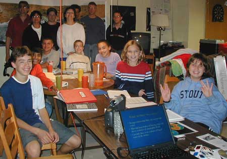
The Phobo Deimos Lego™ League group with advisors
Wisconsin Weather Stories, a joint project of UW–Madison’s Folklore Program, its Cooperative Institute for Meteorological Satellite Studies, and the Wisconsin Arts Board, is helping Wisconsin teachers create a curriculum that “integrates the scientific and socio-cultural aspects of weather,” according to On Wisconsin(Winter 2003), the campus alumni magazine. Two seniors in the Department of Atmospheric and Oceanic Science and three in the Folklore program are working with five teachers scattered throughout the state to gather weather stories and lore to form the basis of lesson plans. The project is supported with funds from the Ira and Ineva Reilly Baldwin Wisconsin Idea Endowment. The Duluth, MN News Tribune published an article on the project after the reporter visited Russ Bailey’s science class in Maple, WI’s Northwestern Middle School while project member Claire Schmidt instructed students in the art of interviewing. ReporterSteve Kuchera recounted weather stories of Colton TePoel, a 13-year-old student, and Lake Nebagamon resident Paula Davis. TePoel noted that “the tornado that hit their place a couple of years back … ‘took off the machine shed roof [and] … picked up one of our big feed bins and threw it about a mile.’”
Margaret Mooney, former National Weather Service meteorologist now with SSEC’s Office of Space Science Education, gave a public lecture at UW Space Place on Tuesday, December 9 at 7:00 p.m. Mooney’s area of expertise is weather satellites. She spoke on “How Satellites Monitor the Global Environment” and focused on work done at UW–Madison’s Space Science and Engineering Center. Space Place is at 1605 S. Park St. on Madison’s south side; it offers a public lecture on the second Tuesday of every month..
Honors
Citations—Twenty-nine of the most cited scientist authors are at UW–Madison. Grace Wahba, professor in the Department of Statistics and an SSEC collaborator, especially with the Isentropic Analysis and Modeling Group, is among them. The list, published by Thomson ISI, a leading citation indexing company, covers 23 broad areas of study across the world from 1981 to 1999. “Having your work cited by your colleagues is high praise,” said Martin Cadwallader, dean of the UW–Madison Graduate School. “It tells you that your work is valued by others and is being used by many people in your field as a foundation for understanding and advancing new knowledge.” Wisconsin Week Wire noted the achievement on December 3, 2003.
Thanks to Tom Achtor, Steve Ackerman, Leanne Avila, JoAnn Banks, Bill Bellon, Allen Huang, Bob Knuteson, Matthew Lazzara, Sanjay Limaye,Christine Molling, Margaret Mooney, Mark Mulligan, Jean Phillips, Dave Santek (all of SSEC), Andy Heidinger and Jeff Key(ASPT), and Ethan Dicks and Darryn Schneider (AMANDA) who provided help and material for this issue.