Riders On the Storm
Hurricanes first take shape in the Atlantic Ocean as tropical storms. They may spin out their violence over the high seas, or they may strike crowded coastlines with devastating effect, causing an average of over $10 billion worth of damage every year. Predicting their paths and intensities is of vital importance.
Over the past several decades, hurricane track forecasts have improved significantly, but storm intensity forecasts have not. Although the path that a hurricane ends up taking is largely dependent upon large-scale environmental winds, its intensity is determined by a wide range of influences, large and small, that occur deep inside its swirling clouds, making prediction very difficult.
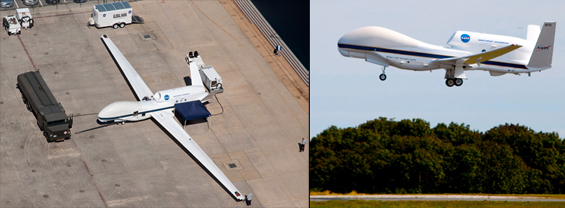
In the last week of September 2012, a Grumman-Northrop Global Hawk unmanned drone, laden with scientific instruments, spiraled up into the atmosphere just off the east coast of the United States. At its cruising altitude of 70,000 feet, guided by researchers sitting safely in a control room at NASA’s Goddard Space Flight Center Wallops Flight Facility in Virginia, the drone headed out over the Atlantic to find Tropical Storm Nadine.
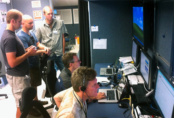
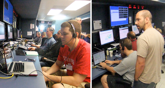
Control Room at NASA’s Goddard Space Flight Center Wallops Flight Facility.
From left to right: Ralph Kuehn, Joe Taylor, Steve Dutcher, Dave Tobin (all SSEC)
and Mission Scientist Paul Newman (NASA GSFC).
Photo by Jonathan Gero (SSEC).
As part of NASA’s five-year Hurricane and Severe Storm Sentinel (HS3) mission, the Global Hawk provides an ideal platform to investigate hurricane formation and intensification. The aircraft is designed for high altitude flights at 385 mph and can stay aloft over 30 hours without refueling.
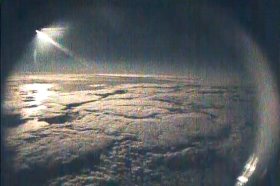
The vehicle’s range enabled it to fly over 3,000 miles across the Atlantic, nearly to the coast of Africa, where it spent 10 hours at 70,000 feet altitude, launching dropsondes and gathering S-HIS data, observing Nadine’s tropospheric conditions, and then returned safely to its base. The Global Hawk made five such flights this season.
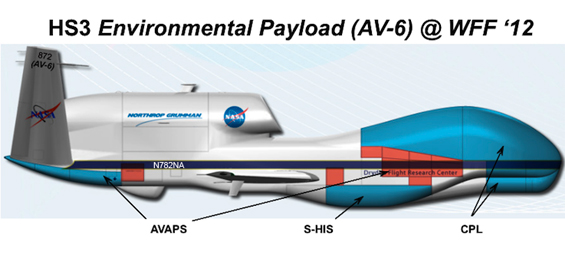
The first year HS3 environmental aircraft payload included the Advanced Vertical Atmospheric
Profiling System (AVAPS) that measures temperature, relative humidity, and wind
with dropsonde packages, and a Cloud Physics Lidar (CPL), in addition to the S-HIS.
Among the instruments on the drone was the Scanning High-Resolution Interferometer Sounder (S-HIS), designed and built at SSEC. The S-HIS measures atmospheric emitted spectrally resolved radiances with one wavenumber resolution from 3 to 17 microns to within an absolute radiometric accuracy of better than 0.5K (3-sigma). SSEC-developed programs are used to compute vertical atmospheric profiles of temperature and water vapor at half-second intervals.
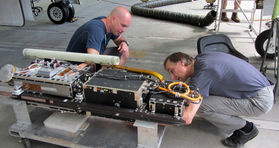
SSEC engineers Joe Taylor and Nick Ciganovich check out the
Scanning High-Resolution Interferometer Sounder before installation.
The overall mission support software required the expertise of dozens of programmers, technicians and communications experts from NASA, industry, and research institutions worldwide. The S-HIS in-flight product generation system was a collaborative effort, principally implemented by Dave Tobin, Elisabeth Weisz, David Hoese, and Ray Garcia with the support and input of many scientists and engineers at SSEC.
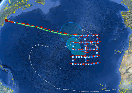
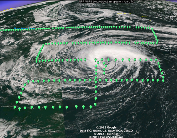
Global Hawk flight, intercepting Tropical Storm Nadine in the Eastern Atlantic.
Note the path of Tropical Storm/Hurricane Nadine originating off the coast of Africa.
Data transmitted from the S-HIS instrument traveled via a satellite link to NASA’s Wallops facility in Virginia, and then over a land line to NASA’s Dryden Flight Research Center at Edwards Air Force Base in California. From there the data was forwarded to SSEC, where researchers received the live S-HIS telemetry and processed the data into human-readable products. The products were forwarded back to the Wallops in Virginia. All that in less than a minute.
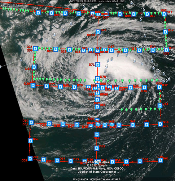
Global Hawk flight. Note the path of Nadine.
The Global Hawk flight path approaches from the northwest and adopts a “Lawnmower” pattern above the storm. The “D” symbols indicate a dropsonde release. The Global Hawk can carry as many as 75 dropsondes — small instrument packages that float down into the storm on parachutes.
The green flags represent soundings taken by the S-HIS.
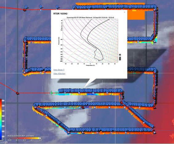
Detail of S-HIS data. Note frequency of soundings (blue dots).
The band under the blue dots is the temperature (scale on left side of screen – 200K to 300K).
Blue shades indicate cloud height and orange a clear view of water.
Previous research suggests that hurricanes strongly interact with their environment at upper levels, but few direct measurements have ever been obtained at these heights. The mission studied the inner core region of Nadine to characterize the role of deep thunderstorms in hurricane intensity change.
Scientists from the Cooperative Institute for Meteorological Satellite Studies (CIMSS) at UW contributed to the field phases of the HS3 project by providing real time satellite imagery, products, and analysis tools for mission planning, forecasting, and post analysis.
Using merged HS3 and satellite observations the mission specifically investigated:
- Upper-level warm core evolution and outflow patterns,
- Inner core structure changes, and
- Near-environment moisture interactions.
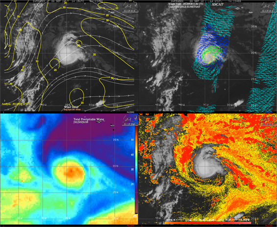
Sample of real time satellite-derived products during TC Nadine on 28 September 2012.
Top Left: CIMSS wind shear analyses. Top Right: ASCAT pass with near-surface wind vectors.
Bottom Left: Microwave-derived Total Precipitable Water. Bottom Right: Split-window dry air product.
Those products, in combination with those retrieved from other instrument packages, allow mission scientists to do hurricane science “as it happens.”
This hurricane season, the Global Hawk flew five times out over the ocean, riding above the storm, peering deep into Nadine reveal the secrets within the turbulence. SSEC’s S-HIS instrument provided unprecedented clear-air and low-cloud environmental sampling surrounding the tropical cyclone, offering fresh perspectives on the mysteries of how they grow and intensify.
The findings from this and future missions will provide much needed insight into the influences of environmental conditions, such as moisture, vertical wind shear, and Saharan dust, on Atlantic tropical storm intensity.
Tropical Storm Nadine was generous to the North American continent – she kept to herself out in the middle of the Atlantic Ocean – she was, however, a long-lived storm event and provided an excellent target for study by the Global Hawk drone. The Global Hawk overflights of Nadine in September caught her at different stages of evolution, and acquired several dozen gigabytes of infrared spectra at half-second intervals that will be analyzed to learn more about the hurricane lifecycle.
Of course, there is no guarantee that the next storm, and the next hurricane season, won’t be much less forgiving. The science of the 2012 Global Hawk flights focused on the formation, intensification, de-intensification, and death of tropical cyclone Nadine. We may not be able to control hurricanes, but more accurate predictions of their strength will provide better warnings, saving human lives and property. More flights will follow in the hurricane seasons of 2013 and 2014.
photos courtesy of NASA.

