Choosing NEXRAD Level II Radar Data
The Radar->Level II->Remote chooser allows you to choose Level II radar data from a remote THREDDS server. For more information on how to use this chooser, see Getting Started - Displaying Level II Radar Imagery.
Local Level II Radar Chooser
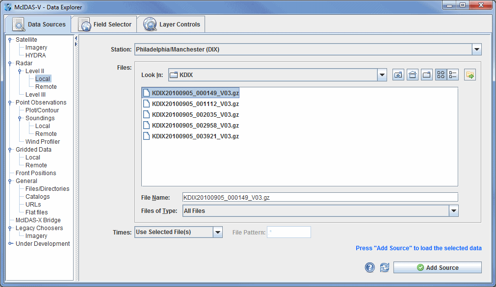
The Radar->Level II->Local chooser allows you to choose Level II radar data from your file system. The Level II data is supplied as volume-scan files, each file having all data from one WSR-88D radar for all sweeps for one "time". Archived Level II radar files can be displayed through the Radar->Level II->Local file chooser. The files should be stored on your file system with each station's files in a directory (folder) whose directory name is the station 4-character ID (e.g., KTLX for Oklahoma City). In some cases, the data files do not have any location information in them, and McIDAS-V uses the directory name as a first guess at the station location. Archived Level II data is available from the National Climatic
Data Center (NCDC).
 Image 1: Level II Local Radar Chooser
Properties
- Station - Selects the radar station for the data. By default, McIDAS-V will use the folder name to determine the radar location.
- Look In - Allows you to select folders to search for data files.
 Up One Level - Moves you up one folder level in your local file system.
 Desktop - Takes you to the Desktop folder of your local file system.
 Create New Folder - Creates a new folder.
 List - Switches the view to a listing of all folders and files in the current path.
 Details - Switches the view to a detailed list of all folders and files in the current path.
 Show History Menu - Shows a list of the last 15 folders that data was loaded from.
- File Name - Represents the file name. Select a file to populate the entry box to show the full name of the file selected.
- Files of Type - Represents the file type. This narrows down the files shown in a folder to a specific data type.
- Times - Represents the times of the radar displays. These times can be individually set, or you can use a File Pattern to display the images in specific intervals.
- File Pattern - Specifies the pattern for files to look for if Times is set to "Use most recent N files".
 Help - Brings up this help page.
 Refresh - Updates the Level II radar chooser with the most recent data.
 - Loads the selected radar data.
Remote Level II Radar Chooser
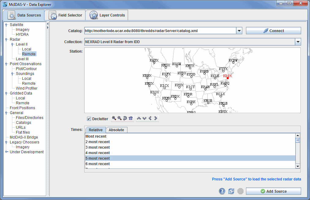
 Image 2: Level II Radar Remote Chooser
Properties
- Catalog - Selects the catalog used to access the Level II radar data.
 - Connects to and queries the server for available radar types and stations.
- Collections - Selects the collection to use.
- Station - Displays the stations related to the selected catalog and selection. Select a station by clicking on the station displayed on the map. The Declutter checkbox allows you to show all stations (not checked), or only a limited number of stations that do not overlap each other (checked). You will need to zoom in to see all the stations without overlaps. Use the Zooming and Panning options to locate a station, or the following buttons:
 Zoom In - Zooms in over the current map area.
 Zoom Out - Zooms out over the current map area.
 Previous Map Area - Returns to the previous map area.
 Home Map Area - Returns to the default map area.
 Move View Up - Moves the view up (map down).
 Move View Down - Moves the view down (map up).
 Move View Left - Click to move the view left (map right).
 Move View Right - Click to move the view right (map left).
- Times: Relative - Allows you to select a group of up to the last 100 times.
- Times: Absolute - Allows you to choose one or more absolute times. When choosing absolute times for the first time McIDAS-V needs to query the ADDE server for the times. This may take some time. To select more than one time use Ctrl+click or Shift+click. See the Timeline Controls section for details on its use. Click on the
 Select Day button to narrow down a large dataset to one day.
 Help - Brings up this help page.
 Refresh - Updates the Level II radar chooser with the most recent data.
 Cancel - Cancels the query of data and stations. The chooser will reset back to default.
 - Loads the selected radar data.


 Help - Brings up this help page.
 Refresh - Updates the Level II radar chooser with the most recent data.
 - Loads the selected radar data.
 Help - Brings up this help page.
 Refresh - Updates the Level II radar chooser with the most recent data.
 - Loads the selected radar data.