Overview
Maps in McIDAS-V are shown using the Map Display Controls. There are two ways these controls are used: for the default background maps and for a user created map display. The control window is composed of two tabs, Maps and Settings.
The Maps tab lists the set of available maps:
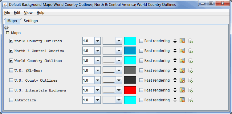
Image 1: Maps Tab of the Map Controls Window
Properties
 Apply changes to all visible maps - Applies any changes to only the one map you modify. When clicked, this icon changes to
  , where any change made to one map will be applied to all of the currently visible maps.
- Maps - Lists the set of currently loaded maps. The maps displayed in the Main Display window are are checked.
 - Selects the thickness of the map line.
 - Selects the style of the map line.
 - Selects the color of the map line.
- Fast Rendering - Save rendering time by not checking for projection seam crossings. Some maps display better when fast rendering is turned on, others display better when it's turned off. If a map displays poorly (e.g., has missing line segments), try switching its fast rendering settings to see if it fixes the problem. See the Fast Rendering section of the User's Guide for more information on this feature.
 Move the map up/down - Shifts the map up and down in the list.
 Remove the map - Removes the selected map from the list.
 Load this map as a data source - Places the selected map in the Field Selector tab of the Data Explorer, where you can display the map with the Map Display or with the Omni Control display. This feature allows for adding multiple maps to one tab in the Main Display window.
The Settings tab allows the user to control the latitude/longitude lines and control the vertical position of the maps:
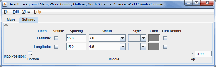
Image 2: Settings Tab of the Map Controls Window
Properties
- Apply changes to all lat/lon lines - When this is selected, any change made made to either the Latitude or Longitude will apply to both, making the Latitude and Longitude displays identical.
- Latitude/Longitude lines - Changes the spacing, width, line style, and color of the lat/lon lines. The Visible checkbox, when checked, will display the lat/lon lines on the map. These controls allow you to display latitude and longitude lines. There is also an option to choose to turn on Fast Rendering.
- Map position - Sets the vertical position of the maps.
Menus
Many of the menu items seen utilizing this display are standard options that can be found in the Menus section of the Layer Controls Page. However, there are some options that are unique to this display.
The File menu has this unique option:
- Default Maps - The Save as the Default Map Set menu item will save the maps you have selected and reopen them next time you open McIDAS-V. The Remove Local Map Defaults menu will undo any saved changes by the user, and will revert back to the initial default map display of McIDAS-V. Note: This option will take a restart of McIDAS-V for the changes to take effect.
The Edit menu has these unique options:
- Add Your Own Map... - Opens an Add a map window, where you can enter a URL of a map or the name of the file saved to your computer. Here, you can name the map, and select the style, color, and width of the map lines.
- Add System Map... - Allows you to select a list of different system maps to add to the list of maps in the Maps tab.
The View menu has this unique option:
- Maps - Allows you to select which maps are checked in the Maps tab, and thus what maps are displayed in the Main Display window.