« Back to "Super Cyclonic Storm Amphan - 17-19 May 2020"
Super Cyclonic Storm Amphan – 18 May 2020
Posted: May 18, 2020
At 09:00 UTC of May 18, Amphan intensified into a Super Cyclonic Storm and within 12 hours, the storm had developed an eye. On 17 May 2020, the 2100Z the Joint Typhoon Warning Center (JTWC) stated that Amphan winds of 130knts, or ~149mph. This would make it a Category 5 storm in the Atlantic basin.
RSMC New Dehli estimated maximum sustained winds at 21Z of 125knts or roughly 144mph, which would make it a Category 5 storm in the Atlantic
Three satellites, NOAA-20, S-NPP and GCOM-W1, observed Amphan providing insights into the storm. This discussion is broken into two parts: VIIRS and microwave imagery
VIIRS
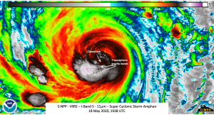
S-NPP first observed Amphan first at ~1938Z with a near nadir pass, while NOAA-20 had a pass with Amphan on the eastern edge of the scan at ~2028Z. As you would expect both NOAA-20 and S-NPP showed the defining characteristics of a mature tropical cyclone. These included convection surrounding the circulation center along with cold cloud top temperatures and tropospheric gravity waves. In addition, the two passes 50 minutes apart provided some insight into the temporal movement of the storm
Interestingly, the open eye yesterday was not present in the I05 (11μm) imagery.
This was noted in the JTWC discussion at 21Z on 18 May 2020.
NM SOUTH-SOUTHWEST OF KOLKATA, INDIA, HAS TRACKED NORTH-
NORTHEASTWARD AT 08 KNOTS OVER THE PAST SIX HOURS. ANIMATED ENHANCED
INFRARED SATELLITE IMAGERY INDICATES THAT TC 01B HAS SIGNIFICANTLY
WEAKENED OVER THE PAST SIX HOURS, IN RESPONSE TO AN EYEWALL
REPLACEMENT CYCLE, WITH THE EYE ACTUALLY FILLING AND DISAPPEARING
FROM INFRARED IMAGERY OVER THE PAST HOUR.THE INITIAL POSITION IS
PLACED WITH HIGH CONFIDENCE BASED ON THE 9 NM EYE EVIDENT IN GOES-IO
SATELLITE...
In case you were curious, GOES-IO was originally GOES-13. The the 03Z JTWC discussion on 19 May 2020 mentioned that
SATELLITE IMAGERY DEPICT A WEAKENED SYSTEM WITH A UNIFORM CENTRAL DENSE OVERCAST
(CDO) AND NO EYE, AT LEAST NOT IN THE VISIBLE OR INFRARED BANDS.
something also seen in the two VIIRS I05 (11μm) images.
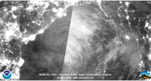
The waning crescent moon (16% illumination) meant that features continued to be illuminated by emitted lights from cities as well as airglow. The convection and intensity of Amphan was strong enough to produce mesospheric gravity waves. These could be faintly seen in the both the NOAA-20 and S-NPP imagery
Also of note is a lone lightning streak in the near nadir S-NPP imagery on one of the outer bands
If one expands out the view using the 1848Z and 2028Z NOAA-20 passes, one can see the extent of these faint mesospheric gravity waves.
Microwave
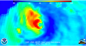
Three microwave instruments could see Amphan, though the near nadir S-NPP pass at 1938Z and the near-nadir AMSR2 pass at 1953UTC provided the best insight into the storm. Both showed that the convection was heavily on the western side, with the ATMS imagery seeming showing the eye opening in the eastern side
Interestingly, the JTWC forecast discussion at 21Z did not utilize both the ATMS or AMSR2 data (due to when the data arrived), but it did mention the indications of the secondary eyewall being open on the eastern side
THERE HAVE BEEN NO MICROWAVE PASSES SINCE A 1514Z AMSU-B
89 GHZ IMAGE WHICH SHOWED THAT THE INNER EYEWALL HAS BROKEN DOWN ON
THE EASTERN SIDE AS WELL AS INDICATIONS OF THE SECONDARY EYEWALL
FORMING, ALSO OPEN ON THE EASTERN SIDE. THE LAST GOOD HIGH
RESOLUTION MICROWAVE WAS A 1211Z CORIOLIS 37 GHZ COLORIZED IMAGE
WHICH SHOWED THE SECONDARY EYEWALL FORMING ABOUT 25 NM OUT FROM THE
CENTER, LENDING HIGH CONFIDENCE TO THE ASSESSMENT OF ONGOING ERC.
In addition, the 03Z JTWC discussion on 19 May 2020 only mentioned the DMSP microwave imagery, which was much closer in time to the discussion time.
SATELLITE IMAGERY DEPICT A WEAKENED SYSTEM WITH A UNIFORM CENTRAL DENSE OVERCAST
(CDO) AND NO EYE, AT LEAST NOT IN THE VISIBLE OR INFRARED BANDS.
THE INITIAL POSITION IN PLACED WITH HIGH CONFIDENCE BASED ON A
182321Z DMSP 89 GHZ COLORIZED IMAGE WHICH SHOWS A NEWLY FORMED
PRIMARY EYEWALL SOLIDLY ENTRENCHED ON THE WESTERN SIDE OF THE
MICROWAVE EYE AT A RADIUS OF ABOUT 18 NM.THE EYEWALL IS OPEN ON
THE EASTERN SIDE OF THE EYE, INDICATIVE OF THE EASTERLY SHEAR AND
MID-LEVEL DRY AIR DEPICTED IN MODEL VERTICAL CROSS-SECTIONS THAT
ARE IMPACTING THE SYSTEM AND PRECLUDING MORE RAPID CONSOLIDATION
OF THE NEW EYEWALL AND COMPLETION OF THE EYEWALL REPLACEMENT CYCLE
(ERC)
The AMSR2 was in-between the two discussions, but showed similar features to those described in the JTWC discussions in the 89.0GHz and 36.5GHz imagery.
Forecasts and impacts
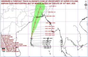
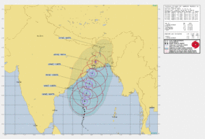
The forecast from RSMC New Dehli and the JTWC show Amphan hitting the Bangladesh coast within the next couple of days as a major tropical cyclone.
The forecast continues to show low-lying and highly populated being impacted in the next several days. With the ongoing CoVID-19 pandemic, this will effect the evacuations and the response to the landfall. The International Charter has been preemptively activated by the Indian government to help aid in the response to the expected major impacts to the storm.


