« Back to "Super Typhoon Hagibis - October 6-13 2019"
Typhoon Hagibis on 6 October 2019
Posted: October 6, 2019
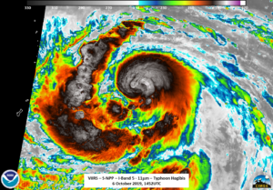
Typhoon Hagibis was a category 3 storm at the time SNPP, NOAA20 and AMSR2 passed over. The first was an edge of scan pas from S-NPP at 1453 on 6 October 2019. At this time, there were no obvious signs of a circulation center, as seen in the high resolution I05 (11μm) image below
though the usual signs of a tropical system could be seen, such as tropospheric gravity waves and overshooting tops. Despite being a Waxing Gibbous moon (58% illumination), the moon was still below the horizon, meaning airglow illuminated Hagibis. However, even though lighting and the cloud tops illuminated by airglow were easily seen, no mesospheric gravity waves were seen in the S-NPP imagery
The NOAA-20 imagery, taken ~50 minutes later at ~1543Z also showed the usual signs of a growing tropical system, though no discernible eye could be seen in the I05 (11μm) imagery.
The cleaner DNB imagery, again illuminated primarily by airglow, did not show any real mesospheric features other than the refelected light from the clouds below. There were also lightning streaks around the convective feeder bands and the lights from Saipan could be seen as well
That being said, both ATMS from NOAA-20 and the AMSR2 pass at ~1554Z (about 10 minutes after the NOAA-20 pass) both revealed the circulation of the storm, which was beneath the convection see in the NOAA-20 11μm, as shown in the two sliders below (ATMS/NOAA-20 11μm and AMSR2/NOAA-20 11μm)
As before, despite the parallax causing some distortions, one can see the rotation of the storm from the NPP and NOAA-20 passes


