« Back to "Typhoon Bualoi - 21-24 October 2019"
Typhoon Bualoi on 22 October 2019
Posted: October 22, 2019
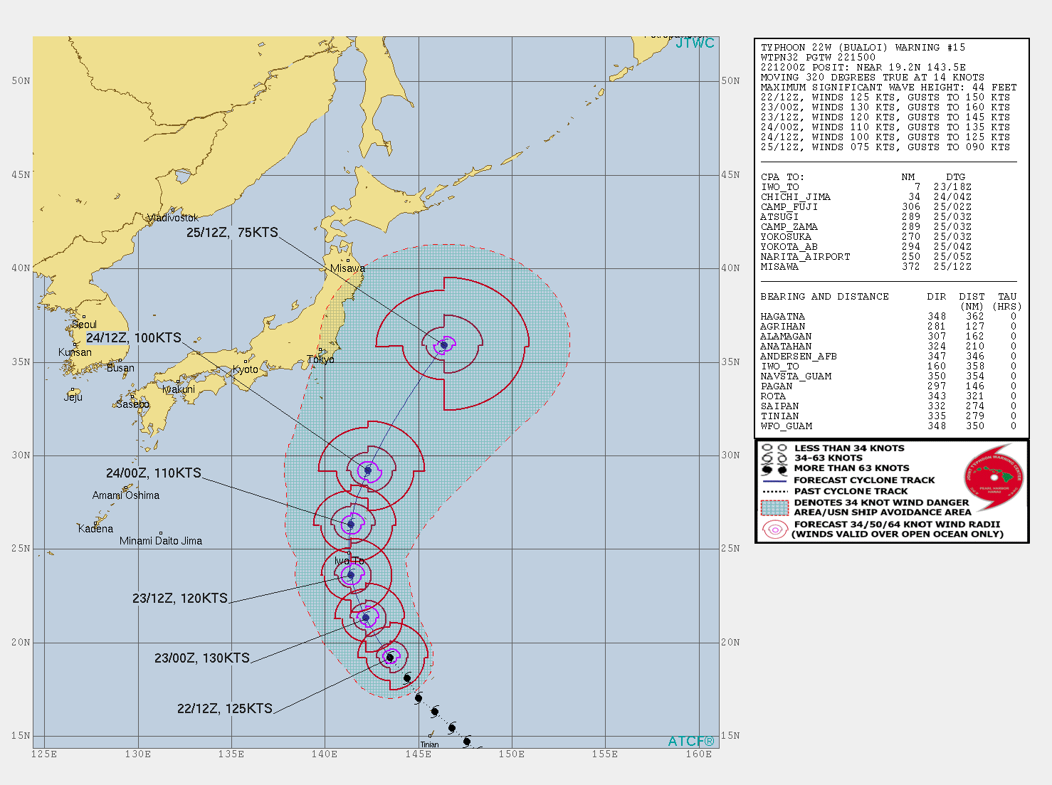
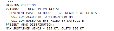
At 1500Z on 22 October, the Joint Typhoon Warning Center (JTWC) stated that Typhoon Bualoi had sustained winds of 125knts or ~143mph, making it equivalent to a Category 4 storm in the Atlantic basin.
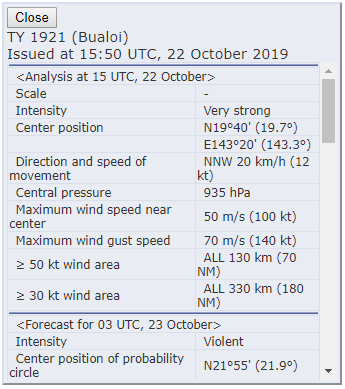
The Regional Specialized Meteorological Center (RSMC) Tokyo stated that the maximum winds at the center were 100knts (~115mph). The difference is due to differing methods of determining the winds and due to the fact that JTWC adopts a 1 min mean wind speed, but RSMC Tokyo adopts 10 mins mean wind speed.
NOAA-20 was the first satellite to see Typhoon Bualoi at ~1543Z just on the western edge of nadir. The waning crescent (39% illumination) providing enough illumination to show the expanse of the eastern side of the storm. While there were no mesospheric features in the storm, one could easily see the wide breadth of the storm, as seen in the zoomed-out image below. In addition, with a lone lightning streak near the center of circulation, which was easily seen in the DNB imagery, along with the illuminated feeder bands north of the circulation.
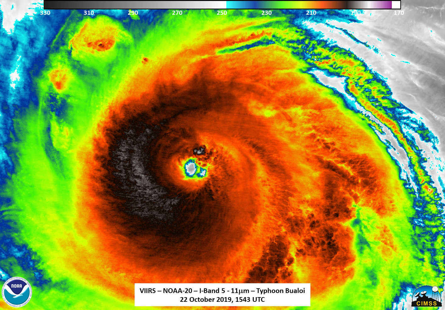
The zoomed out I05 (11μm) reveals a very compact circulation, though it is being fed from several hundred miles away.
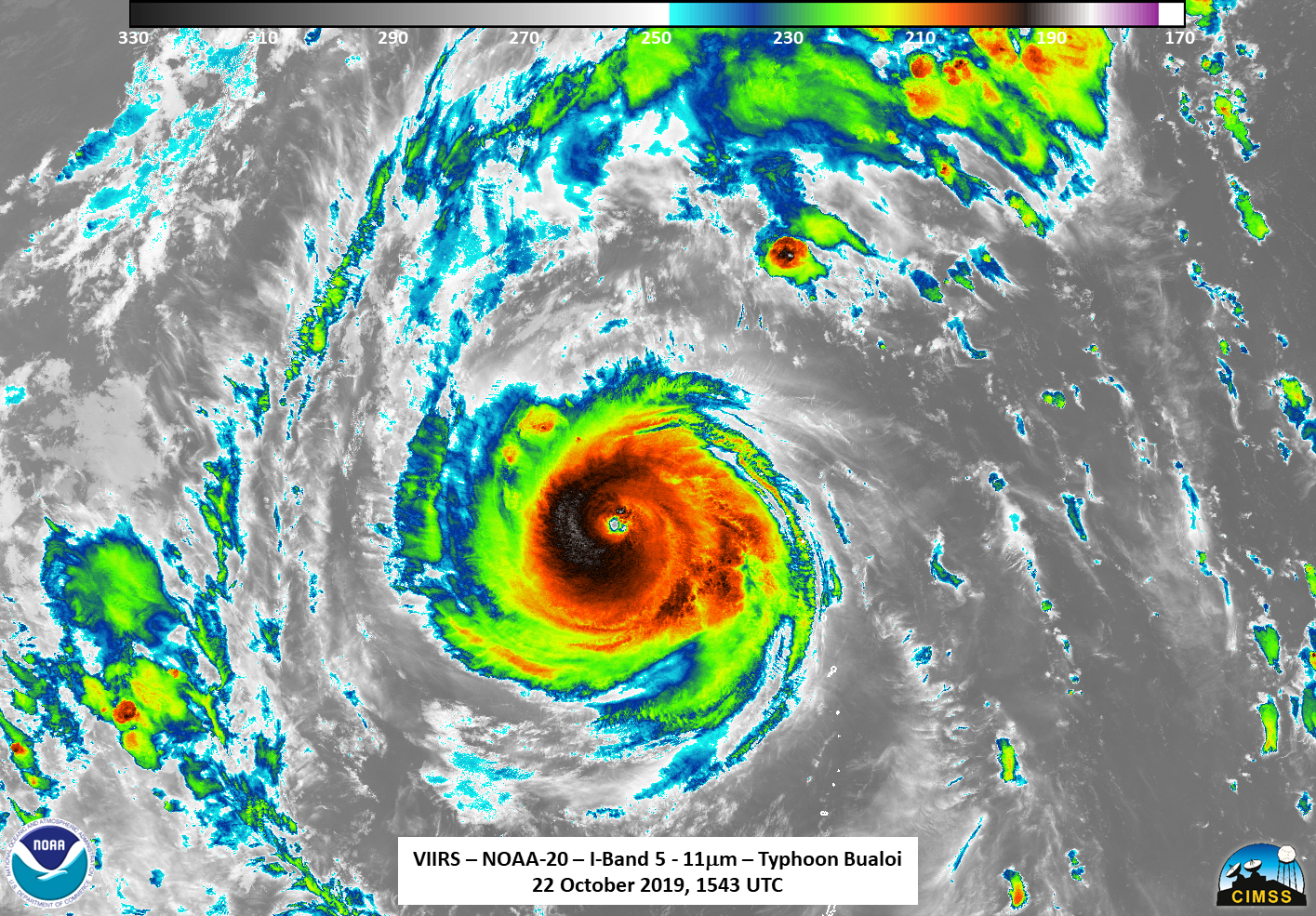
If one zooms in closer to the eye, one can see finer structures, such as the fact that, while the bulk of convection is more on the western edge of the circulation center, it is an asymmetrical storm. The DNB imagery reveals an overshooting top near the circulation center being lit by moonlight or potentially the lightning flash seen in the image.
In addition, what appears to be a second eye can be seen in the I05 (11μm) and DNB imagery.
If one looks at the 2.5-minute rapid scan Himawari-8 Infrared images from several hours earlier to the NOAA-20 pass, courtesy of the CIMSS Satellite Blog, that the eye quickly cleared out and expanded several hours earlier. However, it became a bit more ragged as another eyewall replacement cycle was beginning towards the end of the loop

AHI Imagery, courtesy of the CIMSS Satellite Blog (credit Scott Bachmeier)
This suggested that what was seen in the I05 (11μm) was not a second eye, rather it was simply a cloud entering the circulation at the time of the pass. Using a slightly zoomed out view of Bualoi, one could look at a comparison of the I05 (11μm) with the ATMS imagery and can see that the coldest part of the storm is not necessarily associated with the convective cloud tops.
Again, this is is evidence that the storm was in an eyewall replacement cycle. In fact, just under 50 minutes later, the GCOM-W1 satellite observed Bualoi at ~1634Z on the edge of the pass. In the 88.9GHz, one could easily see the double eyewall associated with an eyewall replacement cycle.
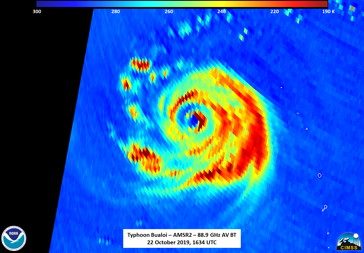
However, if one compares to the 23.8Ghz Brightness temperature, one will notice that the circulation is offset from one another.
This similar to something that NHC had noticed in Hurricane Lorenzo, previously discussed, where the NHC stated the displacement between the low- and mid-level centers (i.e. the two brightness temperatures) of the hurricane was a consequence of persistent wind shear. In the case of Lorenzo, the 23.8Ghz center was displaced to the west as a result of westerly wind shear. In this case, the 23.8Ghz center was displaced to the east, which means there is possible easterly wind shear.
The final satellite to see Bualoi was S-NPP at ~1634Z on the eastern side of the pass. Being on the edge of the pass meant that features were a bit oblong and distorted due to parallax effects. In addition, it meant that the Day Night Band features were somewhat brighter than the ones in the NOAA-20 imagery. As such, the comparison to NOAA-20 from here will be with a different scaling than above to account for this brightness.
The most notable difference between the two scenes is the fact that the eye is completely cloud-covered, as seen in the DNB and I05 (11μm) imagery from S-NPP show a cloud covered eye
Given the location of the storm, one would think that the difference, shown between NOAA20 and S-NPP was only due to parallax.
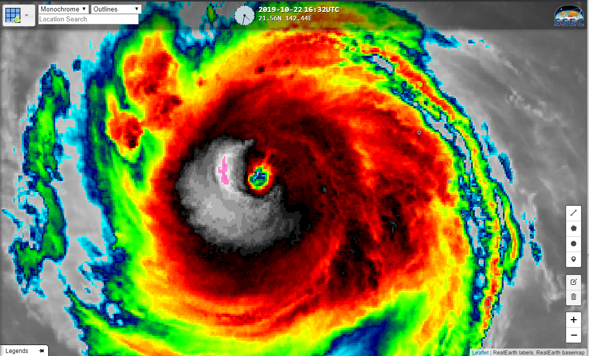
However, if you look at the AHI from Himawari-8, shown below as a screenshot from RealEarth, from roughly the same time, you will see that the eye in Band 14 (11μm) also shows a cloud covered eye.
So while some features are elongated, others are a result of what is happening with the storm. The major difference in the DNB is lunar lighting conditions as well as a lack of lightning streak.
Bualoi is expected to remain a strong tropical cyclone over the next day and intensify slightly as it continues to make the turn to the north, moving well east of Japan, per the Joint Typhoon Warning Center forecast and JMA, both in fairly good agreement on the rough timing and direction of the storm.