« Back to "Hurricane Storm Dorian Aug 28 - Sep 6 2019"
Major Hurricane Dorian from morning of 31 Aug
Posted: August 31, 2019
As people are aware, at 0030 on 31 August, Hurricane Dorian strengthened to a major Category 4 Hurricane overnight, with winds of 130mph, according to the National Hurricane Center. By 0300Z, Dorian had winds of 140mph, which continued through the 0600Z advisories. As of the 1200Z advisory, Hurricane Dorian had winds of 145mph. Recall that a category 5 hurricane has winds of 157mph or higher.
NPP, GCOM-W1 and NOAA-20 all passed over Dorian in that order, right around the 0600Z advisory, each observing unique (and surprising) features. This discussion will step through the VIIRS imagery first and then move on to the microwave instruments (ATMS and AMSR2).
At ~0558 UTC (1:58 am EDT), SNPP caught Dorian on the west side of the scan, meaning that the DNB imagery, while lit by airglow (due to the moon phase being a waning crescent moon with 2% illumination) was not able to pick out a lot of features due to the noise at the edge of scan.
However, the well defined (refined?) eye could easily be seen, along with the different cloud bands and a lone lightning streak on the southern part of the storm. the IR imagery could also see the eye very easily, along with tropospheric convective gravity waves flowing away from the intense storm.
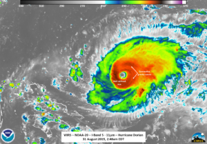
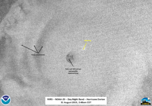
Roughly 50 minutes later at ~0648UTC (2:48 am EDT), NOAA-20 flew over Dorian closer to nadir. Again the IR imagery continued to show convective gravity waves, cirrus blowoff.
In addition, the successive passes showed the rotation of the storm at high resolution.
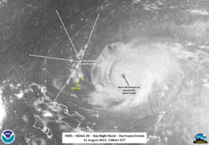
The zoomed out Day Night Band imagery showed the structure of Dorian quite well, even though there was no moonlight present, along with mesospheric gravity waves being flung far away from the storm.
However, if you zoomed in to the eye itself, it appears that there are mesovorticies within the eye, which are an indication of the intensity of the storm, and were not really seen in the S-NPP imagery.
These are not normally seen unless under moonlight or during the day and might only be faintly seen in the I05 imagery. A comparison of the zoomed in (unlabeled) I05 and DNB imagery is shown below
While a well defined eye allows forecasters to get an idea of the center of circulation, this is only really possible once a storm is well developed. In addition, aircraft and dropsonde information provide excellent information about the surrounding environment of the storm, but at select points within the storm. When available, microwave imagery provides an idea of the structure within the entire storm in addition to being used as input to forecast models. The 88.2 GHz BT on the ATMS instrument on NOAA-20 and MiRS rainrate product derived from ATMS easily shows the circulation, though did not show the eye itself.
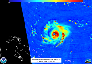
Fortunately, just before NOAA-20 passed over Dorian, the AMSR2 instrument on GCOM-W1 caught Dorian on the western side of the scan and easily saw the well defined eye as well as hints of maybe a secondary set of convection about halfway around the inner eye.
While nothing was mentioned about an eyewall replacement occurring in the 0500Z forecast discussion, the previous forecast discussion at 0300Z mentioned “The eye has become very distinct and is surrounded by a very symmetric ring of deep convection”, something seen in the AMSR2 imagery as well as “The NHC forecast is above the guidance and calls for some additional strengthening in the short-term. After that, fluctuations in intensity are likely due to eyewall replacement cycles that are difficult to predict“. So it is possible that AMSR2 caught one of the eyewall replacement cycles.
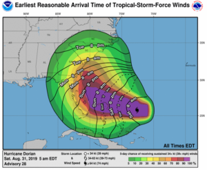
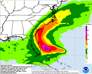
As of the 1200Z public advisory, Dorian is expected to remain a powerful hurricane during the next few days with some possible fluctuations in intensity. The current track has it curving to the north, possibly heading up the eastern side of Florida. Because Dorian is a major hurricane, both strong winds and large amounts of precipitation on an already saturated region are expected.

