« Back to "Hurricane Storm Dorian Aug 28 - Sep 6 2019"
First look at flooding in the Bahamas from SAR
Posted: September 3, 2019
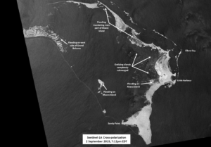
As mentioned in this post, when a region is cloudy, such as the Bahamas are currently, traditional analysis for flooding that rely on visible imagery do not work. Similarly, traditional methods of looking for flooding do not work at night. In the case of Hurricane Dorian, it is likely that the Bahamas will remain cloudy for the next several days. The European Space Agency’s (ESA) Sentinel-1A/B satellites usually have a 12-day repeat cycle in the United States for routine data collection, which NOAA’s Satellite Oceanography and Climatology Division, specifically the Sea Surface Roughness Group at NOAA/STAR, routinely downloads from ESA. As it happens, the area over the Abaco Islands, which have been devastated by a direct hit of a Category 5 Hurricane Dorian, occurred at ~2312UTC (~7:12pm EDT) on 2 September 2019 providing a first look at the affected region. A comparison to the Sentinel-1 cross-polarization imagery from 12 days ago is shown below
Sentinel-1A/B acquired by ESA/Copernicus, provided by Christopher Jackson, NOAA/STAR/SOCD
Contains modified Copernicus Sentinel data 2019
As can clearly be seen in the imagery from last night, area from Marsh Harbour to Great Abaco are completely submerged, with several of the outlying islands in the bay, such as Woods Bay, completely different than the reference imagery. A labeled version with a slightly different enhancement is shown below
Sentinel-1A/B acquired by ESA/Copernicus, provided by Christopher Jackson, NOAA/STAR/SOCD
Contains modified Copernicus Sentinel data 2019
along with a pre/post slider as well
Sentinel-1A/B acquired by ESA/Copernicus, provided by Christopher Jackson, NOAA/STAR/SOCD
Contains modified Copernicus Sentinel data 2019
In the case of emergencies, Copernicus will often provide Sentinel-1 data of the affected flooding regions, even for non-routine imagery. This has occurred with Dorian, where they are providing imagery along the track of Dorian as well as in the potential area for flooding. In other cases, governments can activated Copernicus‘ Emergency Mapping service, which has happened in the case of the Bahamas.
As the storm progresses, SAR data will provided a critical role in mapping the impacts of the floods, especially given how cloudy the region will be.


