« Back to "Hurricane Storm Dorian Aug 28 - Sep 6 2019"
Category 5 Hurricane Dorian from morning of 2 Sept 2019
Posted: September 2, 2019
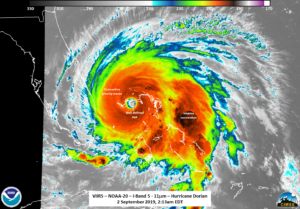
As of the 10am EDT (1200UTC) special advisory Hurricane Dorian was continuing to sit over Grand Bahama island as a Category 5 hurricane, with winds of 160mph and gusts over 200mph according to the National Hurricane Center, with conditions lasting most of today. Because it is approaching the United States, NHC has begun issuing hourly updates on Dorian. At 0600UTC (2am EDT), Dorian had winds of 175mph with hurricane force winds extending outward up to 45 miles according to the NHC public advisory. At 0700UTC (3am) UTC, the winds had weakened slightly to 170mph, but continued to have gusts over 200mph. In all cases, Hurricane Dorian was (and continues to be) a Category 5 hurricane. It is worth noting that yesterday at 1500Z, Hurricane Dorian became the strongest hurricane in history to hit the northwest Bahamas with winds reaching 180mph. By 1800Z on 1 September, Dorian had measured sustained winds of 185mph. This places it in the top 10 strongest tropical cyclones in history, on par with the Labor Day hurricane of 1935, Hurricane Gilbert in 1988, and Hurricane Wilma in 2005.
Unfortunately, the GCOM-W1 pass was to either side of Dorian this morning, meaning it was not able to observe the inner structure. It will be in may be in position later today to observe Dorian. In addition, the thick clouds were enough to obscure both Grand Bahama as well as the Abaco Islands, which had been struck last night. The area the eye was over at the time of the S-NPP and NOAA-20 overpasses was along a mostly uninhabited portion of the Grand Bahama Highway on Grand Bahama. On the best of days, only a few faint lights, which could be obscured by clouds. As such, there will be no comparison imagery of the Bahamas until Dorian passes, which may be a few days from now.
The first satellite to observe Dorian was NOAA-20 at 0613UTC on the extreme western edge of the scan. This meant the eye and other features were shifted due to parallax in the IR and the DNB was not as clean as if it were closer to nadir. However, the classic presentation of a strong hurricane, with a nearly symmetrical circulation, with tropospheric gravity waves coming off the convection surrounding the central circulation could be seen in the high resolution (375m) IR (I05, 11μm) imagery.
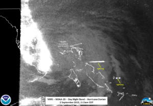
The DNB imagery was basically just the general structure of the storm with a few lightning streaks. In addition, some possible mesospheric gravity waves seemed to be near the circulation center.
Also the lights from the capital city of Nassau could also be seen scattering light through the clouds, which were relatively thinner as compared to areas near the eye of the storm.
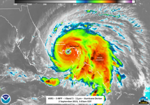
S-NPP, which flew over Dorian ~50 minutes later at ~0703UTC, was in the most ideal position for observing the eye of Dorian at almost near-nadir. As with NOAA-20, the high resolution (375m) IR (I05, 11μm) imagery from S-NPP also showed the classic presentation of a strong hurricane, though slightly rotated around from NOAA-20.
However, due to the fact that S-NPP was looking at Dorian at close to nadir, one did not have any parallax shift. This shift can be seen by looking at the slider below
The waxing crescent moon (14% illumination) meant the storm was entire lit by city lights, such as on the feeder bands over Miami, or by airglow. While S-NPP is much noiser in the DNB than NOAA-20, one could still make out a few possible faint mesospheric gravity waves intermixed with the far feeder bands north of the storm. Also the lights from the capital city of Nassau could also be seen scattering light through the clouds, though easier due to the thinner clouds during the S-NPP pass.
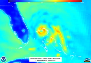
In addition to the imagery from VIIRS, the ATMS microwave sounder was also able to observe the inner structure of the storm. From the 88.2GHz BT, one can easily see the circulation of the storm, with the convection easily being seen as colder temperatures and the warmer temperatures in the eye.
In addition, the MiRS Rain rate product also showed the rain wrapping into the circulation center. One interesting thing is there is a gap in the MiRS rain rate product right over Freeport which doesn’t seem to be associated with anything in the ATMS imagery, which you can see in the slider below
The zoomed in imagery of the ATMS and IR from S-NPP also show good agreement on the location of the location of the most intense convection as well as the concentric (circular) eye, as shown below
This circular eye, along with concentric eyewalls observed by the Bahamas Department of Meteorology radar on Nassau, is one of the reasons that the NHC lowered the intensity of the storm, per the 0900Z forecast discussion.
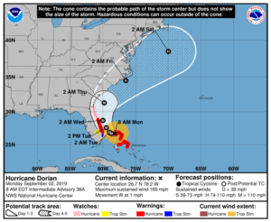
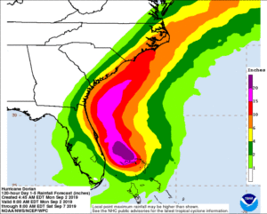
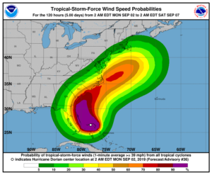
As of the latest forecast track, Dorian is expected to continue to be a major hurricane though the day, and continue the Bahamas. Current guidance is that it will remain a major hurricane through as it tracks along the Florida coast through the rest of the week, impacting Florida, Georgia and the Carolinas. Even a slight change from the current track would result in catastrophic impacts along the coastline

