« Back to "Severe Tropical Cyclone Harold and Vanuatu - 5 - 8 April 2020"
Severe Tropical Cyclone Harold on 7 April 2020
Posted: April 7, 2020
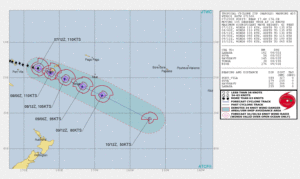
Severe Tropical Cyclone continues to be a very intense storm. At 1200Z on 6 April 2020, Cyclone Harold had estimated winds of 110knt winds (~126mph) with gusts of 135kts, according to the Joint Typhoon Warning Center.
This is equivalent to a Category 3 storm on the Saffir-Simpson scale. At approximately 1322Z on 7 April 2020, NOAA-20 again got a near nadir overpass of Harold as it was just to the southwest of Viti Levu, which is the largest island of Fiji and has a population of approximately 600,000. While still a strong tropical cyclone, as can be seen in the high resolution I05 (11μm) imagery, Harold has lost its noticeable eye. However, there are still is that it is a well defined storm with tropospheric gravity waves, especially coming off the large area of convection on the northwestern side of the circulation.
The full moon (100% illumination), which is also called a “pink moon” and also was a supermoon (i.e a full (or new) moon that nearly coincides with perigee, provided enough ample moonlight to show the visible features of the storm as it passed on the southwest side of Viti Levu.
A lot of the same features seen in the I05 (11μm) imagery from NOAA-20 could be seen in the DNB visible imagery. However, one interesting to note is that while the 11μm there appears to be a closed eye, in the DNB one can see that it appears to just be cloud covered with cirrus. This is more prevalent in the zoomed in imagery, as seen below
Like yesterday, GCOM-W1 flew over Harold, this time close to nadir and approximately ~10min after NOAA-20. It is interesting to look not just at the 89.0GhZ brightness temperature, but also the 29.5GHz brightness temperature. This provides a look at different levels within the storm. As can be seen, the overall circulation is roughly on top of one another. However, the 29.5GHz imagery seems to show a smaller circulation within the larger one.
Also of note is that the ATMS and AMSR2 88.9 and 89.0GHz brightness temperatures are very close to each other. This is not unexpected given the short time difference between the two satellite overpasses of Harold.
The 1500Z forecast graphic from the JTWC continues to show that Harold will impact Viti Levu for the rest of the day before moving off towards Tonga tomorrow.
As mentioned previously, there has been significant devastation seen on the island of Espiritu Santo as well as other islands. Unfortunately, humanitarian assistance is expected to be hampered due to the ongoing CoVID-19 pandemic due to restrictions on travel to Vanuatu. In addition, it is expected that Fiji, especially the island of Viti Levu, will feel the impacts of Harold.


