« Back to "Tropical Storm Nestor"
Potential Tropical Cyclone Sixteen from 18 October 2019
Posted: October 18, 2019
This morning at 0600Z on 18 September, Potential Tropical Cyclone Sixteen had winds of 40mph, according to the National Hurricane Center. By 1800Z, it was named Tropical Storm Nestor, with sustained winds of 60mph.
At ~0741 UTC (~2:42am CDT), S-NPP caught then Potential Tropical Cyclone Sixteen with a near nadir overpass, allowing for the Day Night Band to capture the storm top features in the Waning Gibbous moon ( 80% illumination). Several features could be see, including overshooting tops and tropospheric convectively gravity waves as well as several lightning streaks.
This, along with the strong convective signature in the I05 (11μm) imagery would signal that intensification was likely going on at the time.

In addition, the ATMS instrument on S-NPP caught a hint of a circulation in both the 88.2GHz and MiRS rain rate products.
This is something that is also evident in the VIIRS I05 (11μm) as well, especially when you compare to the ATMS 88.2GHz brightness temperatures
At ~0801Z (~3:01 CDT), GCOM-W1 flew over the storm. Looking at the 23.8 and 89.0GHz imagery also showed a hint of a circulation. However, it was not easily defined in the two levels seen by the AMSR2 scanning radiometer
This lack of a well defined center in the morning of 18 October is something the NHC forecast discussion at 0900Z (4am CDT) from the National Hurricane Center pointed out.
Although the convection associated with the disturbance has increased during the past few hours,
there is no evidence that a well-defined center has formed yet. One can observe several swirls of
low clouds rotating within a larger gyre.
Again, if you look at the Day Night Band imagery from SNPP, one can also almost pick that up, especially if you compare it to the AMSR2 (shown) or ATMS imagery
Unfortunately, due to the position of the storm and orbits of the satellites, NOAA-20 was unable to to a comparison. As of the the 7am CDT advisory, Nestor was forecast to impact the southeast United States.

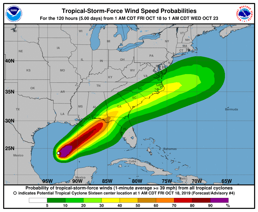
Warning cone, wind forecast and rain totals taken from NHC Graphics page for Tropical Storm Nestor on 18 October 2019 at 8:00am CDT
This track is similar to the 4pm CDT (2100UTC) forecast advisory track.

Warning cone taken from NHC Graphics page for Tropical Storm Nestor on 18 October 2019 at 3:50pm CDT
While this is not a major national level incident, stakeholders, such as FEMA region IV, are currently monitoring the situation for impacts to the Gulf Coast such as flooding and other impacts.

