« Back to "International Charter call for Madagascar - 28 Jan 2020"
NOAA response to floods in Madagascar – 28 January 2020
Posted: January 28, 2020
The government of Madagascar has declared a national disaster in the face of ongoing torrential rain and flooding in the country which started with the arrival of Cyclone Ava and continued through most of the month of January. Because of this, Bureau National de Gestion des Risques et des Catastrophes (BNGRC), the disaster response agency in Madagascar, activated the the international charter was activated.
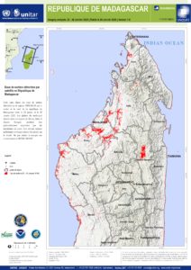
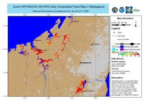
NOAA (JPSS and the Satellite Analysis Branch) collaborated with the Satellite Analysis and Applied Research part of the United Nations Institute for Training and Research (UNITAR), called UNOSAT, to utlize the VIIRS 5-day composite product to produce a information graphic of where the flooding was occurring.
As part of the interaction with BNGRC, UNOSAT also provided direct access to the LEO/GEO flood map website, which allows users to both visualize the product directly as well as download the individual shape files for their own use.
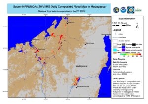
In addition to the above 5-day composite provided by UNOSAT, as shown above, NOAA provided both the 5-day composites as well as additionally providing the 1-day flood extent from 26 and 27 January 2020 along with the shape files as a further value added product.
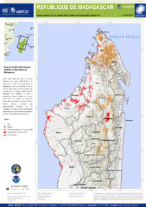
Each of these have been shown to be useful in their own right, from telling where assistance is needed to the amount population that is affected.
In addition to showing where the flooding is located, one can also estimate the number of people impacted, something that UNOSAT also did in this following information graphic along with included shape files for managers to look at.
Finally flooding can also be observed by Synthetic-aperture radar (SAR) imagery from Sentinel-1, collected by NOAA’s Satellite Oceanography and Climatology Division, specifically the Sea Surface Roughness Group at NOAA/STAR. This allows one observe flooding despite any clouds. As shown below, there were areas of flooding in several areas of Madagascar
Sentinel-1A/B acquired by ESA/Copernicus, provided by Christopher Jackson, NOAA/STAR/SOCD
Contains modified Copernicus Sentinel data 2020
The response to this event is on going, with NOAA supporting the response


