« Back to "Hurricane Barbara - July 2019"
Tropical Storm Barbara
Posted: July 5, 2019
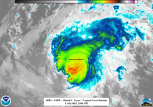
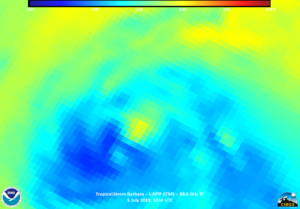
At the 09Z public advisory, Barbara was weakening significantly but was still a Category 1 hurricane (https://www.nhc.noaa.gov/archive/2019/ep02/ep022019.public.020.shtml?) with winds of 80mph. By the 1500Z public forecast, Barbara had been downgraded to a Tropical Storm (https://www.nhc.noaa.gov/archive/2019/ep02/ep022019.public.021.shtml?) with winds of 70 mph. Both the 9Z (https://www.nhc.noaa.gov/archive/2019/ep02/ep022019.discus.020.shtml?) and 15Z (https://www.nhc.noaa.gov/archive/2019/ep02/ep022019.discus.021.shtml?) forecast discussions mention the shearing of the storm. This is something that can be seen in the sole good pass from NPP at ~1034Z in both the IR and ATMS imagery.
What is also mentioned in the 15Z forecast discussion is:
The associated deep convection, which is displaced to the northeast of the cyclone center, is diminishing in both coverage and intensity.
Interestingly, in the DNB imagery, despite being a waxing crescent moon, thus the scene only being illuminated by airglow, there is a suggestion that it observed the exposed circulation to the southwest of the storm, exactly as mentioned in the 15Z NHC forecast discussion.
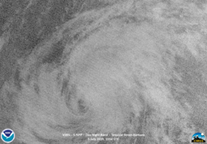
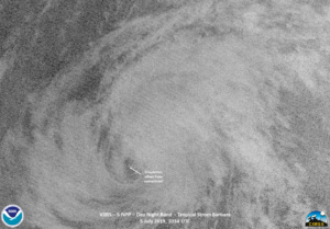
Unfortunately the NOAA-20 extended granule had the storm in the noise, so seeing if this continued was not possible. But this is perhaps another confirmation of what was stated by NHC.

