« Back to "Tropical Storm Barry 11-15 July 2019"
Tropical Storm Barry – 13 July 2019
Posted: July 13, 2019

At 7am CDT (12UTC) NHC public advisory, Tropical Storm Barry had maximum sustained winds of 70 mph and a central pressure of 991 mbar, making it very close to becoming a Category 1 storm (which requires winds of 75 mph). Barry has been very slowly increasing in strength as it inches toward land (movement of 3-5mph).
Barry had very similar characteristics at 12UTC as was seen in the 6 UTC NHC public advisory what is currently the case with winds of 65 mph and a central pressure of 993mbar. In addition, according to the 9Z NHC forecast discussion, Barry continues to have an asymmetric shape,which may be due to some sheer in the region.
Unfortunately owing to the orbital paths of the various low earth satellites, only NPP was the only satellite able to provide a near nadir view of the storm. The waxing gibbous moon (89% illumination) provided an excellent view of the storm and its asymmetric shape. Both the DNB and high resolution IR (I05, 11μm) imagery showed similar features in the convective region, such as overshooting tops and tropospheric gravity waves.
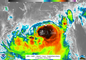
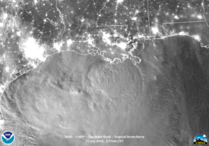
Unlike previous days, the circulation center is not easily seen in the visible or VIIRS IR (I05, 11μm) imagery. It is, however, visible in the ATMS 88Ghz Brightness temperature imagery.
While not normally shown, the Microwave Integrated Retrieval System (MiRS) rainfall rate product, which can be used along with the ATMS brightness temperatures, indicates that the deepest convection and precipitation remain to the south and east of the center of Barry.
For those interested, the MiRS product can be seen in RealEarth over the Lousiana region at the following short URL using data from the CIMSS Direct Broadcast antenna (RealEarth link). This location of the convection verses the center of circulation is also evident when comparing the ATMS brightness temperature with the VIIRS imagery.
And It is also consistent with the NHC forecast guidance states regarding the location of the convection.

Screenshot taken from NHC 4am CDT Forecast Discussion for Tropical Storm Barry on 13 July 2019 at 8am CDT
Given that it is close to the threshold of being a Category 1 storm, it is expected, as of the 9Z forecast, that Barry will likely become a hurricane before it makes landfall later today per NHC forecast guidance. However, the bigger story is that Barry is moving at a slow pace and will bring with it heavy rains over the next several days in the lower Mississippi River valley, as indicated by the latest WPC 7-day rainfall prediction.
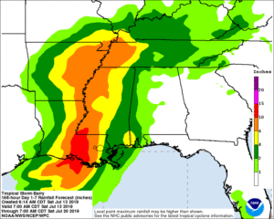
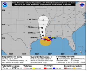
Warning cone and QPE rainfall forecast taken from NHC Graphics page for Tropical Storm Barry on 13 July 2019 at 8am CDT
While there have been some power outages already, most of the areas affected have been cloud covered.


