« Back to "Hurricane Barbara - July 2019"
Hurricane Barbara on 3 July 2019
Posted: July 3, 2019
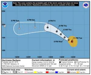
As of the 0900Z public advisory on 3 July 2019 (https://www.nhc.noaa.gov/text/refresh/MIATCPEP2+shtml/030835.shtml), Hurricane Barbara wasa major Category 4 storm with maximum sustained winds of 155mph. In case you are not familiar with the Saffir-Simpson scale, a Category 5 storm is a storm with winds of greater than 157mph. This means that Barbara is on the cusp of becoming a Category 5 hurricane. However, the National Hurricane Center in Miami stated in their forecast discussion that (https://www.nhc.noaa.gov/text/refresh/MIATCDEP2+shtml/030836.shtml) they believe it has reached peak intensity
The lack of imagery from yesterday was certainly made up in this mornings pass with multiple microwave passes from three satellites as well as high resolution IR and Day Night Band imagery. This discussion will step time wise through each satellite. Note that this discussion will be using UTC, since it is right on the change between 2 July and 3 July for HST time, which might make for some confusion.
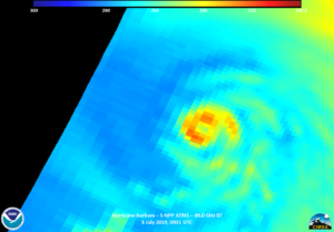
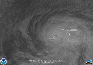
At approximately 0931 UTC, the SNPP satellite had an off-nadir pass of Barbara. This meant that the eye looks slightly non-round in the VIIRS imagery. However, this did not prevent the I05 IR band from seeing the well defined storm, which had a large set of feeder bands along with intense convection as well as tropospheric gravity waves, all indications of a well defined storm.
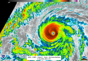
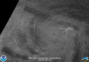
The waxing crescent (1% illumination) meant that over the ocean the only illumination was from airglow. This also meant that one could see the mesospheric gravity waves being emanated from the northeastern side of the storm.
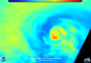
In addition, the ATMS 88.0GHz Brightness temperature showed that while the colder cloud tops surrounded the entire circulation, they were more on the western edge of the storm.
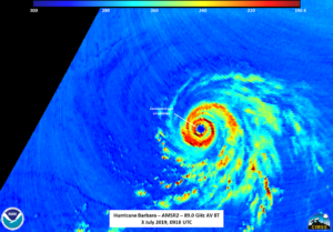
Roughly 30 minutes later, at ~1001UTC, GCOM-W1 with the AMSR2 instrument, flew over Barbara close to nadir. As can be seen in the 89.0GHz imagery, the eye is nearly concentric, with maybe a hint of a double eyewall. This would be consistent with the NHC forecast discussion where they state
![]()
The imagery from AMSR2 seems to agree with this statement, meaning that an eyewall replacement cycle is possibly underway.

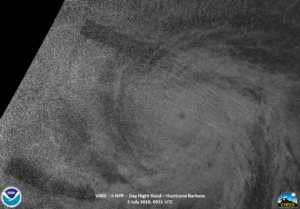
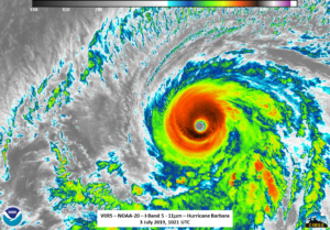
Finally, at approximately 1021 UTC, NOAA-20 had an almost nadir pass of Barbara. This means that any parallax effects are small. One thing to note in the IR imagery is that, in addition to the intense convection and tropospheric gravity waves, the storm looks very circular, though the feeder bands are still present.
In addition to the tropospheric gravity waves, the DNB also showed mesospheric gravity waves in nearly the same location as the NPP imagery.
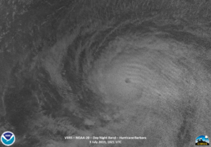
Understanding the coupling of the troposphere and mesosphere, as energy is transferred across all layers of the atmosphere. This coupling was shown in a recent paper published in the Journal of Geophysical Research: Space Physics for a case study from Matthew. (Xu et al., 2019; https://doi.org/10.1029/2018JA026453).
The ATMS imagery also showed colder cloud tops surrounded the entire circulation on the southern edge of the storm, near the convection seen in the IR imagery
Hurricane Barbara is forecast to be a major hurricane through the day today before becoming a depression by this weekend as it approaches the Hawaiian islands.