« Back to "Hurricane Lorenzo - September 27-30"
Hurricane Lorenzo from morning of 29 September 2019
Posted: September 29, 2019
While yesterday Lorenzo was a Category 2 storm. However it restrengthened over the day and by 0210Z, the NHC announced it had restrengthened into a Category 5 storm with winds of 160mph. The 0300Z public advisory also stated that the sustained remained at 160mph, but had decreased to 155mph by the 0900Z public advisory.
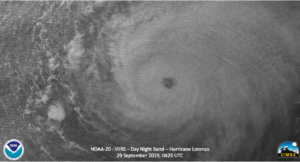
Unfortunately due to the orbit of GCOM-W1, Lorenzo was between two passes this morning, so that means that there was no higher resolution microwave imagery from this morning’s passes. However, Lorenzo was observed by the two operational NOAA polar orbiting satellites, S-NPP and NOAA-20. Lorenzo was first observed by NOAA-20 at ~0425Z close to nadir, allowing the VIIRS and ATMS instruments to get a good look at the storm. As with other strong hurricanes, the eye was well defined along with mesovorticies could seen in the high resolution (375m) 11μm (I05) imagery.
In addition, the mesovorticies could also be seen in the Day Night Band on NOAA-20, which was illuminated entirely by airglow due to the fact the moon was a new moon with 0% illumination.
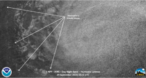
The strength of the storm also was producing mesospheric gravity waves seen in the DNB.
It is interesting to note that in the 88Ghz imagery that at mid levels there was some warmer air near the circulation center, with the colder temperatures being slightly removed from the VIIRS 11μm (I05) imagery, as shown below
This might be an indication of a dry slot in the storm, something that NHC noted in the 0900Z Forecast discussion (https://www.nhc.noaa.gov/text/refresh/MIATCDAT3+shtml/290833.shtml)
The satellite appearance of Lorenzo is not quite as impressive as it was
several hours ago. Although the eye is still very distinct, the cloud tops
are not as cold in the eyewall and there are a few dry slots evident beyond
the inner core.
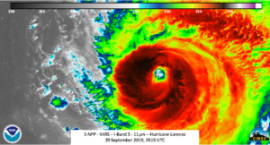
The S-NPP overflew Lorenzo 50minutes later at ~0515Z. Unfortunately it was on the edge of scan, which meant that the imagery from VIIRS was affected by parallax and edge of scan effect. However, similar features in both the I05 and DNB could be seen.
Of course being at a different time means that some of the features were shifted due to the rotation of the storm, which can be seen in the IR image slider below
Lorenzo is now forecast to be a major hurricane through Tuesday before weakening as it heads to the north and northeast, eventually forecast to impact the British isles by Friday.

