Other benefits
Emissivity
With the high temporal resolution and high spectral resolving power, GEO hyperspectral IR sounders will have the capability to characterize the diurnal variations of several geophysical parameters better than GEO IR imagers, including surface emissivity, trace gas, dust, etc. For example, the high spectral resolution emissivity spectra with diurnal variation.
Li, Z., J. Li, Y. Li, Y. Zhang, T. J. Schmit, L. Zhou, M. Goldberg, and W. Paul Menzel, 2012: Determining Diurnal Variations of Land Surface Emissivity from Geostationary Satellites, Journal of Geophysical Research – Atmospheres, 117, D23302, doi:10.1029/2012JD018279. (link)
Li, Jun, Z. Li, X. Jin, T.J. Schmit, L. Zhou, and M. Goldberg (2011), Land surface emissivity from high temporal resolution geostationary infrared imager radiances: Methodology and simulation studies. J. Geophys. Res., 116, D01304, doi:10.1029/2010JD014637. (link)
Li, J., and J. Li, 2008: Derivation of global hyperspectral resolution surface emissivity spectra from advanced infrared sounder radiance measurements, Geophys. Res. Lett., 35, L15807, doi:10.1029/2008GL034559. (link)
Retrievals of trace gases (ozone, CO, NH3, isoprene, N20, etc.)
Beyond highly accurate temperature and moisture profiles, hyperspectral IR sounders allows retrievals of trace gases such as ozone, CO, isoprene, NH3, N2O, etc. Continuous monitoring of those trace gases from GEO will allow better air quality forecasts by monitoring various precursors. The GXS and GeoXO Atmospheric Composition (ACX) sensor will compliment each other. Of course which gases are possible to retrieve depends on the spectral coverage, resolution, SNR, etc.
Shutter, J. D.; Millet, D. B.; Wells, K. C.; Payne, V. H.; Nowlan, C. R.; Abad, G. G. Interannual Changes in Atmospheric Oxidation over Forests Determined from Space. Science Advances 10 (20), eadn1115. https://doi.org/10.1126/sciadv.adn1115.
Vittorioso, F., Guidard, V., and Fourrié, N., (2024). Assessment of the contribution of IRS for the characterisation of ozone over Europe, Atmos. Meas. Tech. Discuss. [preprint], https://doi.org/10.5194/amt-2024-24, in review.
Raghuraman, S. P., Paynter, D., Ramaswamy, V., Menzel, R., & Huang, X. (2023). Greenhouse gas forcing and climate feedback signatures identified in hyperspectral infrared satellite observations. Geophysical Research Letters, 50, e2023GL103947. https://doi.org/10.1029/2023GL103947
Wells, K. C., Millet, D. B., Payne, V.H., Vigouroux, C., Aquino, C. A. B., De Mazière, M., et al. (2022). Next-generation isoprene measurements from space: Detecting daily variability at high resolution. Journal of Geophysical Research: Atmospheres, 127, e2021JD036181. https://doi.org/10.1029/2021JD036181
Wells, K.C., D.B. Millet, V.H. Payne, M.J. Deventer, K.H. Bates, J.A. de Gouw, M. Graus, C. Warneke, A. Wisthaler, and J.D. Fuentes (2020), Satellite isoprene retrievals constrain emissions and atmospheric oxidation, Nature, 585, 225-233, doi:10.1038/s41586-020-2664-3.
Fu, D.J., D.B. Millet, K.C. Wells, V.H. Payne, S.S. Yu, A. Guenther, and A. Eldering (2019), Direct retrieval of isoprene from satellite-based infrared measurements, Nat. Commun., 10, doi:10.1038/s41467-019-11835-0.
Chaliyakunnel, S., D.B. Millet, and X. Chen (2019), Constraining emissions of volatile organic compounds over the Indian subcontinent using space-based formaldehyde measurements, J. Geophys. Res., 124, 10,525–510,545, doi:10.1029/2019JD031262.
Millet, D.B., H.D. Alwe, X. Chen, M.J. Deventer, T.J. Griffis, R. Holzinger, S.B. Bertman, P.S. Rickly, P.S. Stevens, T. Leonardis, N. Locoge, S. Dusanter, G.S. Tyndall, S.L. Alvarez, M.H. Erickson, and J.H. Flynn (2018), Bidirectional ecosystem-atmosphere fluxes of volatile organic compounds across the mass spectrum: How many matter?, ACS Earth Space Chem., 2(8), 764-777, doi:10.1021/acsearthspacechem.8b00061.
Nalli, N.R.; Tan, C.; Warner, J.; Divakarla, M.; Gambacorta, A.; Wilson, M.; Zhu, T.; Wang, T.; Wei, Z.; Pryor, K.; Kalluri, S.; Zhou, L.; Sweeney, C.; Baier, B.C.; McKain, K.; Wunch, D.; Deutscher, N.M.; Hase, F.; Iraci, L.T.; Kivi, R.; Morino, I.; Notholt, J.; Ohyama, H.; Pollard, D.F.; Té, Y.; Velazco, V.A.; Warneke, T.; Sussmann, R.; Rettinger, M. Validation of Carbon Trace Gas Profile Retrievals from the NOAA-Unique Combined Atmospheric Processing System for the Cross-Track Infrared Sounder. Remote Sens. 2020, 12, 3245. (link)
Van Damme, M., Clarisse, L., Whitburn, S., Hadji-Lazaro, J., Hurtmans, D., Clerbaux, C., and Coheur, P.-F.: Industrial and agricultural ammonia point sources exposed, Nature, 564, 99–103, https://doi.org/10.1038/s41586-018-0747-1, 2018. (link)
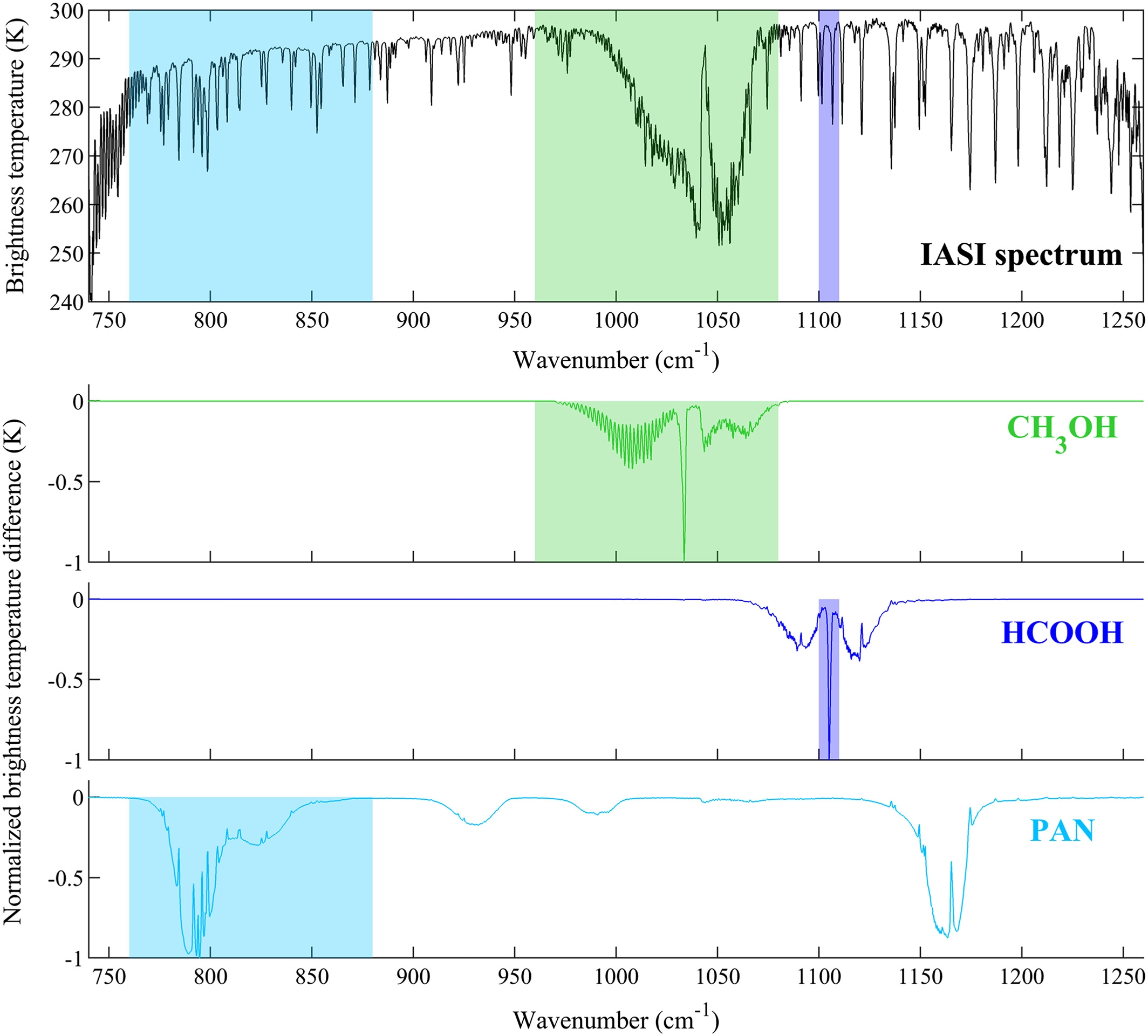
Franco, B., Clarisse, L., Stavrakou, T., Müller, J.‐F., Van Damme, M., Whitburn, S., et al. (2018). A general framework for global retrievals of trace gases from IASI: Application to methanol, formic acid, and PAN. Journal of Geophysical Research: Atmospheres, 123, 13,963–13,984. https://doi.org/10.1029/2018JD029633 (link) See Figure 2.
Liu, Quanhua & Xiong, Xiaozhen & Iturbide-Sanchez, Flavio & Liu, Xu & Wu, Wan & Gambacorta, Antonia. (2016). Retrievals of trace gases from hyperspectral sounders. 353-355. 10.1109/IGARSS.2016.7729085.(link)
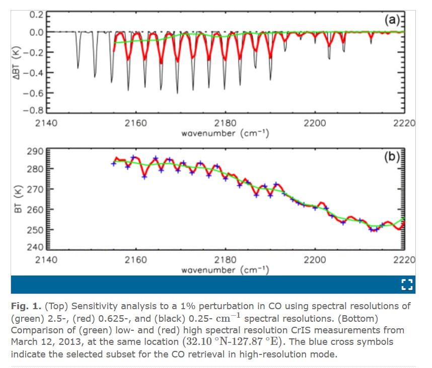
A. Gambacorta et al., “An Experiment Using High Spectral Resolution CrIS Measurements for Atmospheric Trace Gases: Carbon Monoxide Retrieval Impact Study,” in IEEE Geoscience and Remote Sensing Letters, vol. 11, no. 9, pp. 1639-1643, Sept. 2014, doi: 10.1109/LGRS.2014.2303641. See Figure 1.
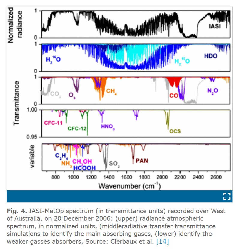
B. K. Ane, “Remote sensing: Searching better accuracy for greenhouse gasses monitoring,” 2013 International Conference on Computer, Control, Informatics and Its Applications (IC3INA), 2013, pp. 17-22, doi: 10.1109/IC3INA.2013.6819141. See Figure 4.
Chahine, M.T., and co-authors (2006) AIRS: Improving Weather Forecasting and Providing New Data on Greenhouse Gases. Bulletin of the American Meteorological Society: Vol. 87, No. 7, pp. 911-926. (link)
Barnet, C.D., M. Goldberg, L. McMillin, and M.T. Chahine (2004), Remote sounding of trace gases with the EOS/AIRS instrument, in Atmospheric and Environmental Remote Sensing Data Processing and Utilization: an End-to-End System Perspective, H.-L. Huang and H.J. Bloom (Eds.), 5548, 300–310, Society of Photo-Optical Instrumentation Engineers, Bellingham, WA, USA. (link)
Natraj, V., Luo, M., Blavier, J.-F., Payne, V. H., Posselt, D. J., Sander, S. P., Zeng, Z.-C., Neu, J. L., Tremblay, D., Wu, L., Roman, J. A., Wu, Y.-H., and Dorsky, L. I.: Simulated Multispectral Temperature and Atmospheric Composition Retrievals for the JPL GEO-IR Sounder, Atmos. Meas. Tech. Discuss., 15, 1251–1267, https://doi.org/10.5194/amt-15-1251-2022, 2022.
Dust
Sokolik, I. N., 2002: The spectral radiative signature of wind-blown mineral dust: Implications for remote sensing in the thermal IR region. Geophys. Res. Lett., 29, 2154. doi:10.1029/2002GL015910.
Yao, Z., J. Li, H.-J. Han, A. Huang, B. J. Sohn, and P. Zheng, 2012: Asian dust height and infrared optical depth retrievals over land from hyperspectral longwave infrared radiances, Journal of Geophysical Research – Atmosphere, 117, D19202, doi:10.1029/2012JD017799.
Yao, Z., Jun Li, and Z. Zhao, 2015: Synergistic use of AIRS and MODIS for dust top height retrieval over land, Advances in Atmospheric Sciences, 32, 470 – 476. (link)
Yao, Z., Jun Li, Z. Zhao, L. Zhu, J. Qi, and H. Che, 2019: Extracting Taklimakan Dust Parameters from AIRS with Artificial Neural Network Method, Remote Sensing, 11, 2931; doi:10.3390/rs11242931.
Inter-calibration
The high spectral accuracy from the hyperspectral IR sounders such as AIRS, IASI, and CrIS on polar orbiting satellites allows them to be used as benchmark to inter-calibrate other sensors. This is particular useful for GEO sensors like ABI, GOES Imagers, and SEVIRI etc, see the Global Space-based Inter-Calibration System (GSICS) at WMO, NOAA, and EUMETSAT. For polar orbiting sensors, the inter-calibration is somehow limited due to mis-match in time and angle unless both are on the same platform. GEO hyperspectral IR sounders, will allow inter-calibrate co-hosted GEO imagers and polar orbiting sensors, including broadband imagers and hyperspectral IR sounders. Below shows selected studies on inter-calibration using hyperspectral IR sounders. Besides, there are a number of publications on GSICS here.
Goldberg M., G. Ohring, J. Butler, C. Cao, R. Datla, D. Doelling, V. Gärtner, T. Hewison, B. Iacovazzi, D. Kim, T. Kurino, J. Lafeuille, P. Minnis, D. Renaut, J. Schmetz, D. Tobin, L. Wang, F. Weng, X. Wu, F. Yu, P. Zhang and T. Zhu., 2011: The Global Space-based Inter-Calibration System (GSICS), Bulletin of the American Meteorology Society, 92, 467475, DOI: 10.1175/2010BAMS2967.1
Hewison, T.J., and M. König, 2008: Inter-Calibration of Meteosat imagers and IASI. Proc. of the 2008 EUMETSAT Meteorological Satellite Conf., Darmstadt, Germany, EUMETSAT. (link)
Tobin, D. C., H. E. Revercomb, C. C. Moeller, and T. S. Pagano (2006), Use of Atmospheric Infrared Sounder high–spectral resolution spectra to assess the calibration of Moderate resolution Imaging Spectroradiometer on EOS Aqua, J. Geophys. Res., 111, D09S05, doi:10.1029/2005JD006095.
Synergistic application with GEO imager
ITSC-20 has made a recommendation to operational NWP centers: Consider including a map of the sub-pixel information derived from imager pixels within hyperspectral sounder FOVs, should bandwidth allow (link). The high spatial resolution IR imagers allow improved sounder sub-pixel cloud characterization, which is beneficial for radiance assimilation. A good example of this synergistic application is use imager for IR sounder cloud-clearing, i.e. MODIS for AIRS (Li et al. 2005) and VIIRS for CrIS (Wang et al. 2014, 2015, 2017)
Wang Pei, Jun Li, Z. Li, A. H. N. Lim, Jinlong Li, T. J. Schmit, and M. D. Goldberg, 2017: The Impact of Cross-track Infrared Sounder (CrIS) Cloud-Cleared Radiances on Hurricane Joaquin (2015) and Matthew (2016) Forecasts, Journal of Geophysical Research – Atmospheres, 122, DOI: 10.1002/2017JD027515. (link)
Wang, P., Jun Li, M. Goldberg, T. J. Schmit, et al., 2015: Assimilation of thermodynamic information from advanced IR sounders under partially cloudy skies for regional NWP, Journal of Geophysical Research – Atmosphere, 120, doi:10.1002/ 2014JD022976.(link)
Wang, Pei, Jun Li, Jinlong Li, Zhenglong Li, Timothy J. Schmit, and Wenguang Bai, 2014: Advanced infrared sounder subpixel cloud detection with imagers and its impact on radiance assimilation in NWP, Geophysical Research Letters, 41, 1773 – 1780. (link)
Economic benefits
An Investigation of the Economic and Social Value of Selected NOAA Data and Products for Geostationary Operational Environmental Satellites (GOES) by CENTREC (2007) found estimated potential benefits from improved information from GOES-R satellites for the following five specific types of economic activities:
- Improved tropical cyclone forecasting resulting in more effective action to protect property and to enable evacuation of individuals residing in the path of the storm: $0.450 billion in 2015 (average of $130,000 per U.S. coastline mile from Maine to Texas) and $2.4 billion from 2015 to 2027 (average of $690,000 per U.S. coastline mile from Maine to Texas)
- Enhanced aviation forecasting resulting in improvements in avoidable delays, value of passenger time avoided, avoidable repair costs due to volcanic ash, and avoidable risk of aircraft/life lost: $0.169 billion in 2015 and $0.768 billion from 2015-2027
- More accurate temperature forecasts contributing to improved energy demand expectations and savings in the electricity and natural gas sectors: $0.512 billion in 2015 and $2.56 billion from 2015-2027
- Enhanced forecasts leading to more efficient irrigation of crops — resulting in water savings, energy savings by not having to pump water, and revenue gains from selling excess water: $0.061 billion in 2015 and $1.09 billion from 2015-2027
- Improved forecasting of tropical cyclones resulting in reduced losses to the recreational boating industry: $0.031 billion in 2015 and $0.141 billion from 2015-2027
Across the five activities, the combined annual value for 2015 exceeds $1.2 billion. The value of the combined estimated benefits for the 2015-2027 period approaches $7 billion.
More recently, sounder value assessment report:
Adkins, Jeffrey;Alsheimer, Frank;Ardanuy, Phillip;Boukabara, Sid;Casey, Sean;Coakley, Monica;Conran, Joseph;Cucurull, Lidia;Daniels, Jaime;Ditchek, Sarah D.;Gallagher, Frank;Garrett, Kevin;Gerth, Jordan;Goldberg, Mitch;Goodman, Steve;Grigsby, Ed;Griffin, Michael;Griffin, Vanessa;Hardesty, Michael;Iturbide, Flavio;Kalluri, Satya;Knuteson, Robert;Krimchansky, Alexander;Lauer, Christopher;Lindsey, Dan;McCarty, Will;McCorkel, Joel;Ostroy, Joanne;Pogorzala, David;Revercomb, Hank;Rivera, Richard;Seybold, Matt;Schmit, Timothy;Smith, Bill;Sullivan, Pamela;Talaat, Elsayed;Tewey, Kevin;Todirita, Monica;Tremblay, Denis;Vassiliadis, Dimitrious;Weir, Patricia;Yoe, James, 2021: Geostationary Extended Observations (GeoXO) Hyperspectral InfraRed Sounder Value Assessment Report, NOAA/NESDIS Technical Report, 103pp., https://doi.org/10.25923/7zvz-fv26
Some updated values in a 2021 NOAA/NESDIS Technical Report.
Planetary Boundary Layer
- IR sounding is sensitive to the PBL structure and is often able (depending on the type of PBL and the process being analyzed) to realistically depict important PBL properties.
- The AIRS project produces a PBL height dataset over the ocean based on the maximum vertical gradient of relative humidity that correctly represents, from a climatological perspective, key areas over the ocean where spatial variability is known to play a key climate role.
- Recent efforts involving statistical and neural network approaches to perform more ‘targeted’ PBL retrievals from AIRS have shown promise in extracting the signal of typical PBL structure (e.g., convective well-mixed layer and PBL top
inversion).
