Super rapid scan capability: Using today’s technology to simulate future GOES-R improvements

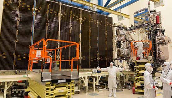
NOAA ASPB scientist Tim Schmit stands in front of GOES-R to demonstrate scale. Credit: Lockheed Martin.
Of the three geostationary weather satellites the United States currently operates, two are used regularly to monitor and predict our nation’s weather (GOES-13 and GOES-15) while the third satellite (GOES-14) serves as a backup. In the last several years, though, that backup satellite has taken on an additional, important role.
Starting in 2012, at the request of scientists at UW-Madison’s Cooperative Institute for Meteorological Satellite Studies (CIMSS), the National Oceanic and Atmospheric Administration (NOAA) has periodically placed GOES-14 in a rapid scan mode in order to gather observations during periods of potential convection or to monitor other rapidly changing phenomena.
This special mode of imaging, known as Super Rapid Scan Operations for GOES-R (SRSOR), is spearheaded by NOAA Advanced Satellite Products Branch (ASPB) scientist Tim Schmit, who is based at CIMSS. The process is intended to help prepare future users of GOES-R mesoscale data.
The one minute imagery gathered during these intensive observing periods simulates the significantly improved temporal resolution that will be possible with next-generation satellite GOES-R, scheduled to launch on November 4, 2016.
Recently, Schmit took a few minutes to reflect on the role that he and other CIMSS scientists have played in SRSOR, the upcoming GOES-R launch, and previous GOES satellite missions…
What is a typical day in SRSOR mode like for you?
Each day, I send an email to a small group of forecasters and scientists to let them know what [weather features or conditions] we are considering looking at the following day. With the one-minute data, we are only able to see a small region, so you have to decide [in advance] where you want to look. Not surprisingly, the people who study convection are most interested in looking at places where storms are likely to develop.
The regions of interest might include convection, fog, fires and smoke, blowing dust, tropical disturbances, hurricanes, and even small volcanoes.
We have a spirited discussion, and once we reach some kind of consensus—for better or worse, they let me have the final say—I reach out to the satellite operators and request that location.
Then, [the next day], we verify that the images returned are in the correct location, monitor the imagery, and post animations over regions of interest. Next, we begin discussions on the location of the special sector for the following day.
Has the project been rewarding for you?
With scientific research, generally, you write a paper and hope someone will read it. In contrast, this research is very applied. It’s affecting National Weather Service (NWS) operations, getting people ready, so that when we get the data from ABI (the Advanced Baseline Imager, the Earth-viewing imager instrument onboard the GOES-R series) we will have a better idea of how we want to use the data, imagery, and what new products can be developed with it.
Of course there are many who have helped to make these special data possible: From the satellite operators to those who help ingest and disseminate the information to the many who use the data in their application area.
How is the SRSOR one-minute imagery better or different than what you normally get from the other two U.S. geostationary satellites?
Often when you look at a satellite loop of cloud motions from the current GOES, the clouds just kind of jump every 15-30 minutes [the time between available images], but the one-minute [satellite imagery] is more fluid as things change—the transitions are smooth.
“
”Unique ‘rapid scan’ views from the GOES-14 imager in SRSOR mode (center panel) compared to GOES-15 (left panel) and GOES-13 (right panel). Credit: CIMSS.
Every year we’ve asked for, and received, more and more data [from GOES-14], and more people have been using it and requesting certain events. We’ve supported NWS forecast offices, the NOAA NWS Storm Prediction Center, the Aviation Weather Center, the Weather Prediction Center, the National Hurricane Center, Scott (Bachmeier and Lindstrom) with the CIMSS Satellite Blog and other science bloggers, field experiments (such as Plains Elevated Convection At Night (PECAN) in 2015) on the research side, and others. I even broke down and created a Twitter account to interact with our users. The more users we’ve had, the more interesting it’s gotten, because they come up with new things to look at.
And when scientists, forecasters, and others get excited about it, I tell them to just wait until we have GOES-R data, because it will be even better. While the GOES-14 satellite provides one-minute data, it does not provide the improved spatial resolution that will be possible with GOES-R. And, it does not have the extra spectral bands.
I say, “If you like GOES-14 one-minute data, you’ll love GOES-R data!”
How will your role change once GOES-R is launched?
For us, GOES-R is a continuation of what we’ve done for previous satellites. After the satellite is launched and before it is operational [sends back data], we support a post-launch test. The post-launch test consists of an engineering check-out—does the instrument work? And a science check-out when we run through routine schedules, generate derived product images and derived fields, and make sure everything looks good before it is deemed operational. There are a number of NOAA scientists at CIMSS who are involved in this testing through the Algorithm Working Group: Andy Heidinger leads the cloud team, Mike Pavolonis leads aviation, Jeff Key leads cryosphere, and I lead the imagery and atmospheric soundings teams. And each team includes a number of CIMSS researchers, depending on their area of expertise.
When the satellite reaches geostationary orbit, that’s when the satellite’s letter becomes a number. So, for instance, GOES-R will become GOES-16. Soon thereafter, SSEC’s Data Center will be busy getting the data and SSEC/CIMSS scientists will use the data to conduct research.
How have the GOES satellites changed over the years?
Well before GOES—in the mid-1960s—NASA launched the Applications Technology Satellites (ATS). Two of those satellites carried a special camera called the spin-scan cloud camera (SSCC) into geostationary orbit. The camera was developed here at SSEC by Verner Suomi. His idea to observe cloud motions from a satellite proved successful. The launch of the first GOES satellite in 1975 was followed by two others, GOES-2 and -3, in the mid-1970s. Each of them had an imager similar to the SSCC as well as one visible and one infrared channel. The next big step came with GOES-4, which included more infrared bands. We have had the same imager on our weather satellites since GOES-8, which was launched in 1994. And the number of infrared bands – four – and visible bands – one – has remained the same since 1994 as well.
But the big step up, of course, is the GOES-R series. The ABI will have faster coverage (one image every minute over small areas; 5 minutes versus 15-30 minutes currently over the contiguous U.S.), finer spatial resolution, and 16 imager bands (as compared to the 5 today).
We (working with SSEC/CIMSS and many others) were able to make the ABI more of an advanced instrument by advocating for a higher number of spectral bands, which is what you are seeing now around the world, such as with Japan’s Himawari satellite. Originally, the ABI was slated to have just 8 spectral bands, not the 16 that it now has.
How many more satellites will be launched in this series?
GOES-R, S, T, and U are all in production mode. As far as capabilities, they are all the same. It brings the cost down to buy multiple copies at once. In addition to the 16 imager bands, GOES-R will have a Geostationary Lightning Mapper to look at total lightning, and it will be able to take images of the Sun.
The launch of GOES-R has been highly anticipated by remote sensing scientists across the country, and in particular at SSEC and CIMSS. Using GOES-14 to simulate GOES-R has been critical to understanding and preparing for improved measurements, products, and forecasts. And the benefits of these new, long-studied capabilities will finally be seen in daily operation.
By Jean Phillips and Sarah Witman
